ПЕРСПЕКТИВЫ ОСВОЕНИЯ НЕФТЕГАЗОВЫХ ОБЪЕКТОВ ВИЛЮЙСКОЙ СИНЕКЛИЗЫ
Structural map of the Khapchagay megaswell along the Triassic-Permian boundary (A) and sublatitudinal geological-geophysical section through the Khapchagay oil and gas region (B)
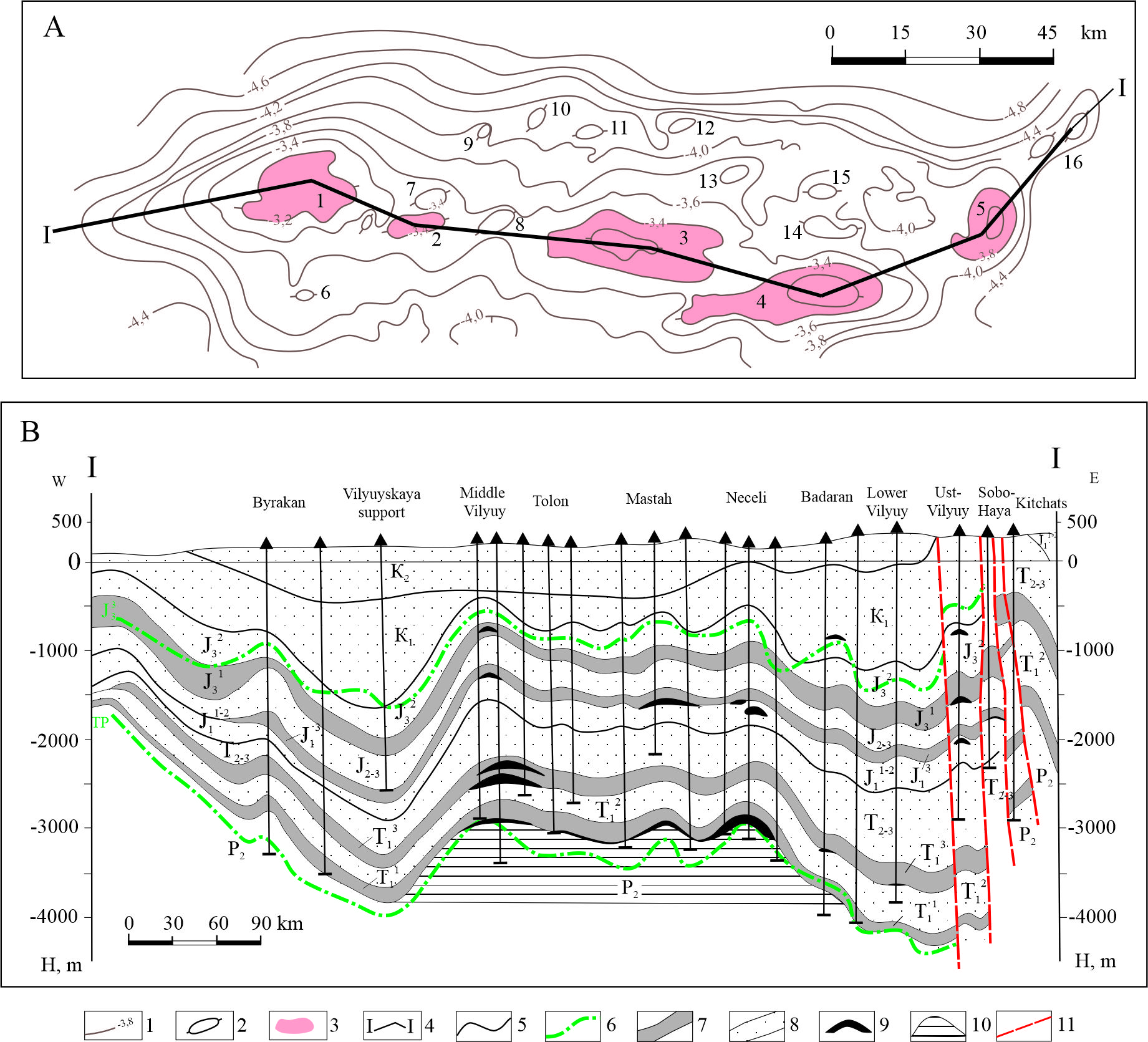
1 - isohypses of the reflecting seismic horizon TP (Triassic-Permian); 2 - local anticlinal structures; 3 - gas condensate fields; 4 - line of the profile geological-geophysical section in the territory of the Khapchagay oil and gas region; 5 - geological boundaries; 6 - reference reflectors; 7 - regional essentially clayey screens; 8 - strata of predominantly sandy composition; 9 - gas and gas condensate deposits; 10 - predicted massive deposit in the Upper Permian sediments; 11 - discontinuous tectonic disturbances;
the structures are marked with numbers on the map: 1 - Sredne-Vilyuiskaya, 2 - Tolonskaya, 3 - Mastakhskaya, 4 - Sobolokh-Nedzhelinskaya, 5 - Badaranskaya, 6 - Severo-Tymtaydakhskaya, 7 - Verkhne-Tolonskaya, 8 - Severo-Kumakhskaya, 9 - Severo-Tolonskaya, 10 - Lonkholokhskaya, 11 - Dzhikindinskaya, 12 - Bezymyannaya, 130 - Vostochno-Bappagayskaya, 14 - Lyuksyugunskaya, 15 - Sredne-Lyuksyugunskaya, 16 - Nizhne-Vilyuiskaya;
lithological and stratigraphic section of the Upper Paleozoic and Mesozoic deposits: P2 - Upper Permian; T1 - Lower Triassic; T11 - Nedzhelinskaya suite; T12 – Taganja Formation; T13 – Monom Formation; T2-3 – Middle and Upper Triassic (Tulur Formation); J1 – Lower Jurassic: J11-2 – Lower and Middle Lias; J13 – Upper Lias (Suntar Formation); J2-3 – Middle and Upper Jurassic; J31 – Marykchan Formation; J32 – Bergey Formation; K1 – Lower Cretaceous; K2 – Upper Cretaceous