Выявление несанкционированных свалок с помощью анализа панорамных снимков: результаты исследования
Выявление несанкционированных свалок с помощью анализа панорамных снимков: результаты исследования
Аннотация
Проблема несанкционированных свалок твердых бытовых отходов, а также строительного мусора крайне актуальна для регионов России, так как представляет серьезную угрозу для водного и экологического санитарного состояния. По данным государственной отчетности Федеральной службы по надзору в сфере природопользования, в настоящее время в Челябинской области, Свердловской области и Республике Башкортостан насчитывается более 1000 обнаруженных и выявленных несанкционированных хранилищ отходов.
Решением проблемы является санитарная очистка свалок с последующей рекультивацией загрязненных территорий. Но перед этим свалки необходимо обнаружить.
Центр исследований и решения экологических проблем «Экопатология» разработал метод, получивший название «анализ панорамных снимков». Этот подход предназначен для обнаружения мест захоронения отходов путем анализа панорамных снимков улиц, находящихся в открытом доступе.
По результатам исследования, проведенного в трех регионах Российской Федерации, было выявлено 29 несанкционированных свалок, загрязнивших более 449 м2 почвы.
Эффективность метода обнаружения мест захоронения отходов путем анализа панорамных снимков составила от 81, 81% до 90%.
1. Introduction
The problem of unauthorized landfills of municipal solid waste and construction debris is highly relevant for the regions of Russia. According to the government reports of the Federal Service for Supervision of Natural Resource Usage three regions of the Russian Federation, namely Chelyabinsk region, Sverdlovsk region and the Republic of Bashkortostan, are polluted by more than 1000 of discovered unauthorized landfills nowadays. Annually due to the citizens’ applications to the local authorities dozens and even hundreds of illegal dumps are found
, , .Inappropriate waste storages pose a real threat to environment and people’s health. Illegal dumps, depending on what they contain can be a potential fire zone and a source of soil pollution and infectious diseases
.The basic solution to the problem is sanitary cleaning of the illegal landfills, with the following remediation of contaminated areas. Unauthorized dumps located on the municipal land plots are cleaned with the help of the local authorities, while the ones located on the private area are taken care of by the owners of the land.
However, firstly, it is necessary to detect illegal landfills before cleaning the area. Since 2022 The Center for Research and Solutions of Environmental problems "Ecopathology" has been taking part in the eco-project "Environmental advocate tools", the aim of the project is to create different ways, methods and approaches to identify unauthorized dumps of municipal solid waste, construction debris and other categories of waste.
In 2022 the organization mentioned above came up with the idea of identifying the illegal waste storages by analyzing satellite images. This method called "Visual satellite search for illegal landfills" focuses on studying openly accessed satellite pictures
. Such an approach demonstrated high efficiency detecting the dumps larger than 100 m2, however, quite low effectiveness was shown while trying to discover the landfills smaller than 100 m2.In order to detect the dumps of a smaller size, the technique of examination of freely accessed panoramic street images was applied. This way has never been used by researchers before, despite the fact that all the panoramic pictures are available in "Yandex maps" and "Google Earth Pro" mapping software.
Research objective – to describe the experience of analyzing the panoramic street images to detect unauthorized dumps.
2. Research methods and principles
The article contains the meta-analysis of the results of the previous research where the technique of analyzing panoramic images was applied. The meta-study was made by The Center for Research and Solutions of Environmental problems "Ecopathology" while conducting the following projects: "Environmental advocate tools", "Ecology monitoring laboratory "Svalok.Net".
The research described was held in the 2nd and 3rd quarters of 2022 in the municipal districts of Chelyabinsk region: the city of Troitsk, municipal district of Troitsk, municipal district of Korkino, municipal district of Yemanzhelinsk, Chelyabinsk.
The object of research also included the municipal district of the Republic of Bashkortostan: Miyakinsky district, Aurgazinsky district, the urban district of Neftekamsk.
During the research, the municipal districts of Sverdlovsk region were also examined: the urban district of Sysert, the city of Yekaterinburg.
In addition, the study provides the analysis of citizens’ applications to the local self-government authorities which were filed during the realization of the research. The aim of this monitoring is to verify the information about unauthorized dumps which was collected using the method of "analyzing panoramic images".
The study also used the general scientific research methods such as: analysis, synthesis, deduction and induction.
3. Analysis of panoramic images
Analysis of panoramic images – is a technique of examination of openly accessed panoramic street pictures. The aim of the method is to detect unauthorized dumps of municipal solid waste, construction debris and other categories of waste.
The minimum required software for the analysis of panoramic pictures is: web browser, "Yandex Maps" mapping software or "Google Maps" mapping software, public land cadaster.
The optimum software is: "Google Earth Pro" application or web browser, "Google Earth" mapping software, public land cadaster.
The "analysis of panoramic images" method consists of the following sequential stages:
1. Defining the boundaries of the territory under research.
2. The search of panoramic views of the studied area or panoramic images of the closest districts – the usage of mapping software with a free access to panoramic pictures.
3. Analyzing panoramas and looking for unauthorized dumps in the area under research.
4. Localization of the detected object: illegal landfill is a plot of land marked on the publicly visible cadastral plan.
According to the Federal Law "On State Registration of Real Estate", a cadastral map (plan) is a depiction of units of real property, showing graphically and textually their location, boundaries, area and type, invariable registration number and other data from the Unified state register of immovable property.
On the stage described above it is possible to differentiate authorized dumps from unauthorized ones as a cadastral map of the particular area holds the information about the type and the designated purpose of the land plot.
5. Filing an appeal to the government authorities responsible for the maintenance of the land plot and to the regulatory authorities.
The appeal is sent to the official website of the state authority or it is filed through the "Gosuslugi. Reshaem vmeste" mobile app. According to the Federal Law "On the Procedure for Considering appeals of Citizens of the Russian Federation", the maximum period of considering any appeals is 30 days.
On the territory of the Russian Federation, in accordance with the Federal Law "On the General Principles of the Organization of Local Self-Government in the Russian Federation",
On the territory of the Russian Federation according to the Federal Law "On the General Principles of the Organization of Local Self-Government in the Russian Federation", local self-government authorities are the ones responsible for elimination of illegal waste storages located on the state land plots. The obligation of maintenance of land plot of physical and legal entities lay on the owners of the land property.
Regional government agencies (for example, regional Ministry of Ecology) and Federal authorities (the Federal Service for Supervision of Natural Resource Usage, the Federal Service for Supervision of Consumer Protection and Welfare, the Federal Service for Veterinary and Phytosanitary Surveillance) monitor the activity of the local self-government authorities and the owners of the land plots. In case of appearance of unauthorized landfills Federal authorities has a right to take local government to court.
To speed up the process of sanitary cleaning or elimination of illegal dumps it is necessary to file an appeal to every authority mentioned above. It is possible to do either through the official websites or through the personal meetings with the representatives of government authorities.
Nowadays, there are ongoing researches to automate the procedure.
3.1. Theoretical justification of the efficiency of the method
In accordance with the results of the previous research called "Catalog of illegal landfills of the city of Chelyabinsk" the average age of unauthorized dumps is 6.4 years. It is noteworthy that there is a direct relation between the age of illegal waste storage and its size. In the Russian Federation local self-government authorities are obliged to take care of inappropriate handling of the waste on the municipal land plots. However, the public funds and money allocated for cleaning the territory is not enough. That is the reason why unauthorized dumps can exist for such a long period
.Panoramic pictures, publicly visible due to "Google Earth» mapping software and "Yandex Maps" Internet resource, can partially or fully show the location of unauthorized dumps. In the captured panoramic pictures dumps are either not removed because of the lack of public money or they appear in the same place after the sanitary cleaning again as the residents got used to store their waste in that place.
3.2. Processing sequence of the "analysis of panoramic images" method
The 1st stage. Geographic area: southern outskirts of the city of Troitsk, Chelyabinsk region. The research was conducted in June, 2022.
The 2nd stage. On this stage the selection of panoramic images with the help of "Google Earth Pro" mapping software and "Yandex Maps" Internet resource took place.
The 3rd stage. The selected panoramic pictures were examined to detect unauthorized dumps. The example of a panoramic image with a spotted illegal landfill is shown in picture 1.
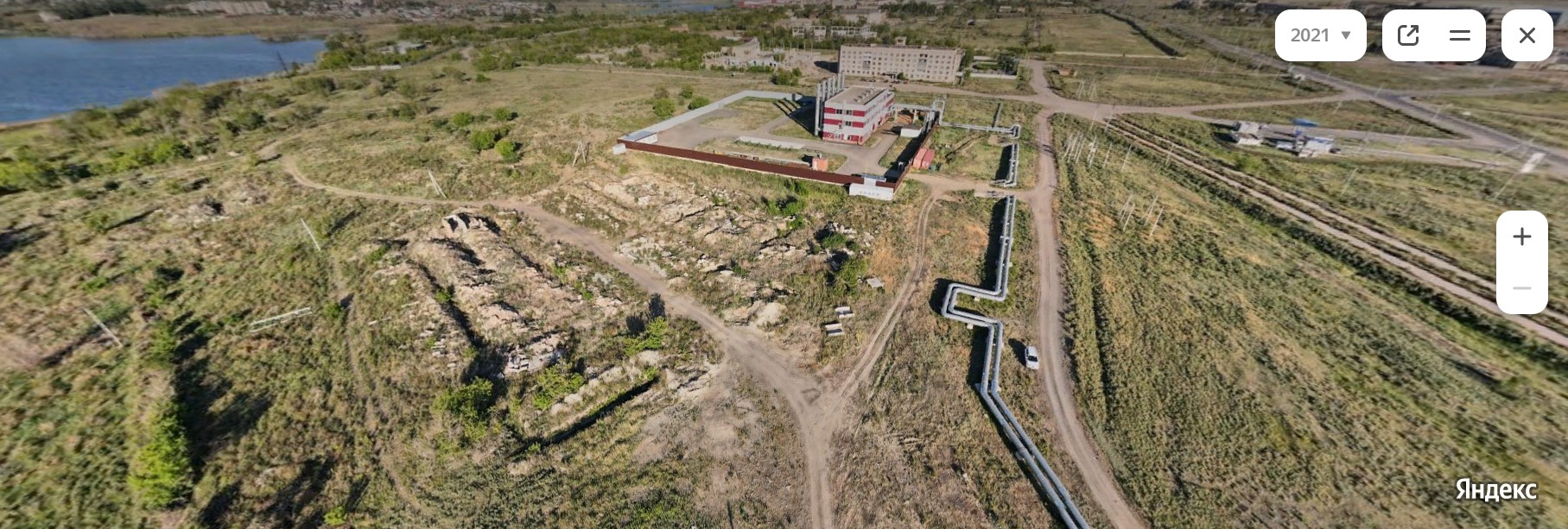
Figure 1 - A panoramic picture with a detected unauthorized dump of a construction waste, drone, 2021
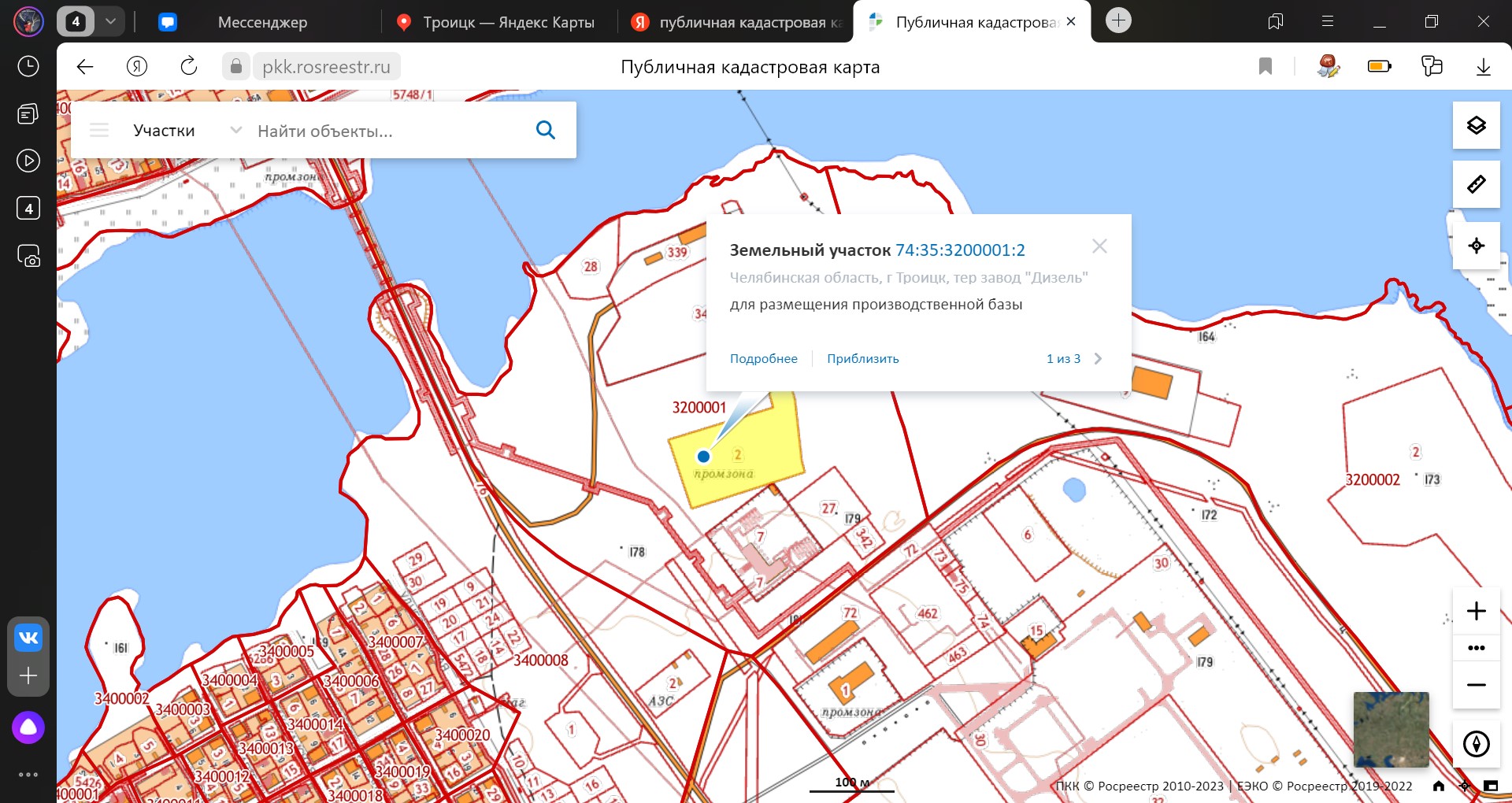
Figure 2 - Publicly-accessible cadastral map with a highlighted land plot where an illegal waste storage is located
30 days after the appeal was filed the response from a city administration came. The landfill was verified and identified. The legal entity, the owner of the land plot, got a warning of inadmissibility of breach of legislation.
3.3. The experience of the use of the "analysis of panoramic images" technology as a method of detecting unauthorized dumps
3 researches with the use of the "analysis of panoramic images" technology were conducted by now. As for the results, 20 unauthorized dumps of municipal solid waste and construction debris were detected.
The summarized data of the results of the conducted researches are presented in spreadsheet 1.
Column "detected dumps" includes all the unauthorized dumps found during the researches. They are combined into the single document which was sent to the local self-government authorities.
Column "verified dumps" includes all the dumps that have been defined by the local self-government authorities as the unauthorized ones.
Column "efficiency of the technique" was calculated as the ratio of the number of verified dumps to the number of detected ones.
Table 1 - Efficiency of the technique
Region of research | Number of detected dumps | Number of verified dumps | Efficiency of the technique, % |
Chelyabinsk region | 11 | 9 | 81,81 |
Sverdlovsk region | 10 | 9 | 90 |
The Republic of Bashkortostan | 8 | 2* / 7** | 25* / 87,7** |
Results | 29 | 25 | 86,5 |
Note: * – according to the results of the local self-government authorities’ checkout; ** – according to the results of the regional authority’s re-inspection
While carrying out the researches the information about 29 illegal dumps and their approximate location emerged. This information was sent in the form of citizens’ appeals to the local self-government authorities responsible for detection of unauthorized dumps of municipal solid waste and construction debris.
The efficiency of the applied technique proved to be 81, 81% in Chelyabinsk region and 90% in Sverdlovsk region. The effectiveness of the method in the Republic of Bashkortostan has significantly decreased, it was 25%. This was the result of the local self-government authority inspection of the discovered illegal dumps. Taking into account a sharp decrease in the efficiency and the lack of properly composed response to the appeal (no date, no photos that would confirm the fact of inspection) it was decided to file a complaint to the Ministry for Natural Resources and the Environment of the Republic of Bashkortostan.
The inspection of the local authorities carried out by the Ministry for Natural Resources and the Environment of the Republic of Bashkortostan brought up two main conclusions. Firstly, the checkout showed the breach of order made by the local authorities while working with citizens’ appeals. Secondly, the checkout confirmed the existence and the location of 7 unauthorized dumps. Considering the new information the efficiency of the technique can be counted as 87, 7%.
As for the 7 verified dumps, the representatives of the government authority pointed out that these newly discovered unauthorized dumps had reappeared again after the sanitary cleaning of the territory.
The rest of the unauthorized waste storages can be considered as the typical example of an unauthorized landfill which was thoroughly described in the research called "Unauthorized landfills are a spontaneous anthropogenic factor in urbanized territories"
.For instance, the following photos of 3 confirmed and verified illegal dumps allow seeing the main components of trash such as: construction debris, foliage and waste from sanitary pruning, wrappings and packaging materials.
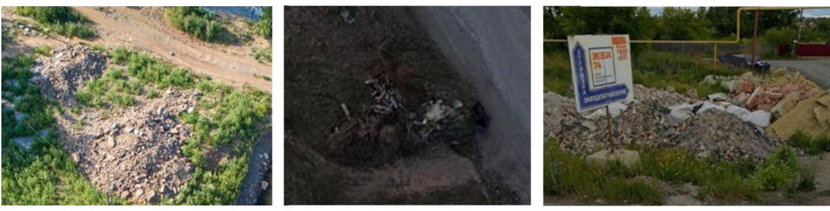
Figure 3 - Screenshots of panoramic images depicting unauthorized landfills
Table 2 - Surface area of the analyzed dumps
Region | Minimum surface area, m2 | Maximum surface area, m2 | Average surface area, m2 | Total surface area, m2 |
Chelyabinsk region | 3 | 64 | 23,11 | 208 |
Sverdlovsk region | 3 | 35 | 13,67 | 123 |
The Republic of Bashkortostan | 2 | 59 | 17,85 | 118 |
Result: | 449 | |||
Consequently, the technique of analyzing panoramic images allows detecting unauthorized landfills with the surface area from 2 m2 to 64 m2. The average surface area of the discovered waste storages is in the range of 13, 67 m2 – 23, 11 m2.
In comparison with the "analyzing panoramic images" technique, the method of detecting unauthorized dumps by analyzing satellite images enables the researches to spot the objects with a surface area of more than 10 – 50 m2. However, the result depends on the quality of the pictures under analysis.
3.4. Advantages of the method
The conducted research highlights the following advantages of the "analysis of panoramic images" method:
1. The technique, as it is, is distinguished by its simple use as it doesn’t require any special knowledge from an individual. It offers new opportunities to different foreign noncommercial associations and civic organizations.
2. The method is based on the analysis of openly accessed data. Consequently, to use this technique one does not have to spend any financial resources.
3. This method allows spotting the location of dumps with a surface area 2 m2. No other way, like analysis of satellite images, can do the same.
4. The "Analysis of panoramic images" technique allows detecting unauthorized dumps which are hidden by natural or artificial obstacles.
5. The information collected in the result of the research can be used to install enforcement cameras in the correct places to track the violators who reappear landfills after remediation of the area.
6. The described method can be applied in educational process. For example, this knowledge can be used while studying Geography, Regional Ethnography or Urban Science as the process of searching for unauthorized dumps provides a researcher with information about the appearance of the city, peculiarities of its districts and street patterns
.4. Conclusion
In conclusion, the research conducted by The Center for Research and Solutions of Environmental problems "Ecopathology" revealed 29 unauthorized dumps on the territory of Chelyabinsk region, Sverdlovsk region and the Republic of Bashkortostan. The method of analyzing publicly accessible panoramic images helped to spot the dumps with their following verification and to define the size of land contamination, which was 449 m2.
The efficiency of the method of analyzing panoramic images is in the range of 81, 81%-90%.
The technique of analyzing panoramic pictures allows detecting illegal landfills with the surface area from 2 m2 to 64 m2. It also helps to spot the land plots with high risk of repeated pollution.