Географическое исследование состояния и использования земель объектами гражданской недвижимости на федеральных охраняемых территориях
Географическое исследование состояния и использования земель объектами гражданской недвижимости на федеральных охраняемых территориях

Аннотация
В статье исследуется состояние и использование земель, занятых объектами гражданской недвижимости, на особо охраняемых природных территориях (ООПТ) федерального значения России. Цель работы — выявление пространственно-правовых диссонансов, оценка экологических последствий антропогенной деятельности и эффективности земельного законодательства. Применена комплексная методология, включающая правовой и кадастровый анализ, ГИС-моделирование, анализ данных дистанционного зондирования Земли (ДЗЗ) и полевые исследования. Эмпирическую основу составили данные Национальной системы пространственных данных (НСПД) и Федеральной государственной информационной системы территориального планирования (ФГИС ТП).
Результаты выявили существенные расхождения между кадастровыми записями, границами населённых пунктов и функциональным зонированием ООПТ, что порождает правовую неопределённость и усиливает экологические риски (фрагментация местообитаний, потеря биоразнообразия, деградация почв). На примере национальных парков «Плещеево озеро» и «Самарская Лука» показано, что несогласованность планировочной документации и устаревшие пространственные данные усложняют оформление прав, увеличивают административные барьеры и снижают эффективность охраны.
Подчёркивается необходимость интеграции экологических критериев в планирование землепользования, оперативного обновления кадастровой информации с использованием современных ГИС-технологий и гармонизации законодательства. Предложены практические рекомендации по оптимизации землеустройства, обеспечивающие баланс между социально-экономическим развитием и сохранением природных комплексов ООПТ.
1. Introduction
The relevance of the study is determined by the increasing anthropogenic pressure on federally protected natural areas (PAs) in the context of civil real estate development. Legal conflicts arising from discrepancies between cadastral data, settlement boundaries, and PA zoning create risks for both the ecological sustainability of these territories and the rights of individuals and legal entities
. Settlements located within PAs are in a zone of special legal and environmental conflict. The specific regime of national parks and nature reserves only exacerbates geographical, environmental, and economic problems .According to Clause 1, Article 3.1 of Federal Law No. 33-FZ dated March 14, 1995 "On Specially Protected Natural Territories" (hereinafter — Federal Law No. 33-FZ), land plots within settlement boundaries can remain with rightsholders when these territories are included in national parks, provided their use complies with the established protection regime. However, as practice shows, the procedure for coordinating types of activities, especially in settlements with unestablished boundaries, becomes economically and administratively burdensome.
This article, based on a comprehensive analysis of legislative acts, territorial planning documents, and geospatial data, identifies key problems affecting the geographical and environmental aspects of activities within PAs
, . The aim of the work is to identify spatial-legal dissonances in the use of PA lands for civil development and to develop recommendations for their minimization based on the integration of GIS technologies, environmental monitoring, and legal analysis.2. Research methods and principles
The object of the study is specially protected natural territories of federal significance — national parks within whose boundaries settlements with active residential development are located.
The subject of the study is the spatial-legal relations arising from the use of land plots for civil real estate objects under a special protection regime.
The research is based on a comprehensive methodology integrating legal analysis, geoinformation modeling, and environmental assessment. The work was carried out according to the following algorithm:
1. Legal and Regulatory Analysis: Systematization of federal and regional legislation (Federal Law No. 33-FZ, the Land Code of the Russian Federation, the Urban Planning Code of the Russian Federation, Federal Law No. 505-FZ), subordinate acts (including Orders of the Ministry of Natural Resources of Russia), and local regulatory documents governing land use within PAs.
2. Collection and Validation of Geospatial Data: Formation of the initial data array from public sources: the National Spatial Data System (NSPD, 2024)
and the Federal State Information System for Territorial Planning (FGIS TP) . To verify cadastral maps and settlement boundaries, up-to-date Sentinel-2 satellite imagery and archival materials were used. The accuracy of spatial data referencing was controlled at a level not lower than 5 meters.3. GIS Analysis and Cartographic Modeling: Spatial analysis was performed in the ArcGIS Pro 3.1 and QGIS 3.28 software packages using overlay, buffering, and spatial statistics tools. A proprietary geoinformation database was created, including the spatial distribution of land plots, PA boundaries and their functional zones, settlement boundaries, as well as data on land use types and environmental restrictions. AutoCAD 2024 software was used to detail territorial planning schemes.
4. Comparative Case Study: For an in-depth analysis, three settlements were selected, representatively reflecting the spectrum of identified problems: the village of Kriushkino (lack of established boundaries), the village of Solomidino (presence of established boundaries), and the village of Brusyany (the problem of "cluster" zoning). The selection criteria were: location in different national parks, different legal status of boundaries, and the presence of conflict situations documented in the public domain.
5. Environmental Assessment: Based on remote sensing data and literature sources, a qualitative assessment of potential environmental consequences of development was conducted: habitat fragmentation, changes in hydrological regime, recreational digression. The assessment methodology included expert analysis and mapping of ecological risk zones.
As part of the study, a geographical database was created designed to analyze the spatial distribution of civilian real estate and to study the mutual influence of anthropogenic activity and specially protected natural areas within the boundaries of national parks. Based on the results of the work, problematic aspects of this interaction were identified, focused on three key elements: "population — protected areas — legislation". The analysis of existing relationships has been carried out, and recommendations have been developed to optimize the living conditions of people in the territories of national parks and adjacent protected areas
, , , .3. Main results
1. Legal Collisions and Administrative Barriers in Construction Approval. The analysis showed that the key factor determining the legal regime of land plot use is the presence of officially established settlement boundaries in the Unified State Register of Real Estate (USRE).
In accordance with Clause 4, Article 15 of Federal Law No. 33-FZ, a resident of a settlement whose boundaries are not established is obliged to coordinate with the Ministry of Natural Resources of Russia measures for the construction of a residential building. The procedure requires providing an extensive package of documents, including materials of the Environmental Impact Assessment (EIA), which entails significant time and financial costs
.Example 1: The village of Kriushkino (Pleshcheyevo Lake National Park). The settlement boundaries are absent from the USRE (Fig. 1). The provisions of Article 3.1 of Federal Law No. 33-FZ do not apply to residents, creating a legal vacuum: they are forced to either wait for the establishment of boundaries or undergo a complex coordination procedure with the Ministry of Natural Resources of Russia. This is economically impractical for individual developers
.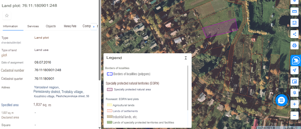
Figure 1 - Land plot diagram 76:11:180901:248, which requires approval of the type of work, map scale 1:2000
Note: source [33]
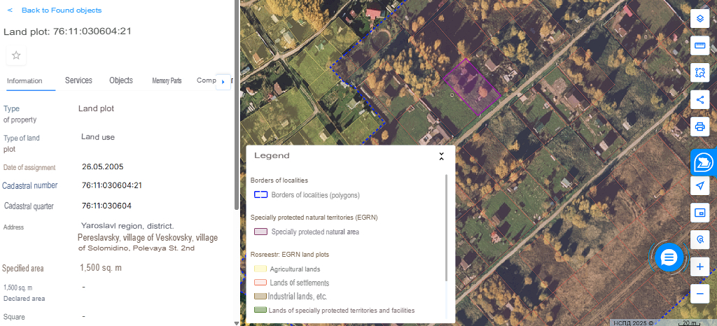
Figure 2 - Land plot diagram 76:11:030604:21, obtained from a geoinformation portal that does not require approval of the type of activity map scale 1:2000
Note: source [33]
Thus, there is an inequality of legal conditions for residents of two neighboring villages, which contradicts the principles of legal certainty and social justice.
Given that municipal administrations bear the financial responsibility for demarcating settlement boundaries for cadastral registration, two key issues require attention: the socioeconomic status of residents within national parks, and the establishment of a streamlined approval process for siting capital construction projects on land plots designated for such use. This study proposes a framework to regulate family residence in these areas. Furthermore, leveraging modern technologies like GIS and remote sensing in document preparation is expected to significantly accelerate the processing of land rights documentation for the studied plots
.2. Problems of Territorial Planning and Zoning. Systemic shortcomings in territorial planning documents and PA zoning have been identified:
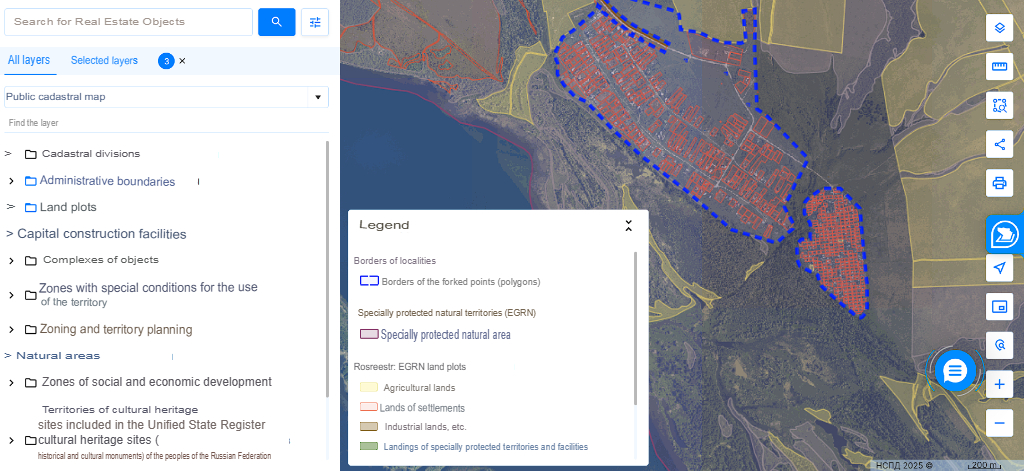
Figure 3 - The village of Brusyany and the farm "Brusyany" on the portal of the NSPD, map scale 1:20000
Note: source [33]

Figure 4 - The map of the urban zoning of the village of Brusyany is presented within the framework of the current rules of land use and development, map scale 1:5000
Note: source [30]
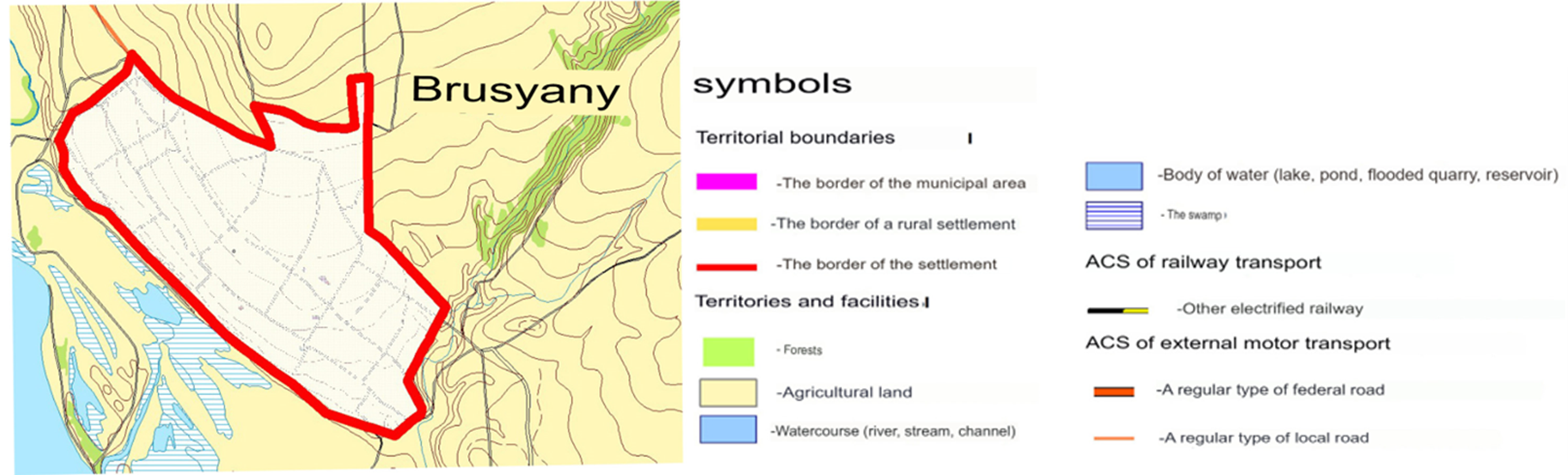
Figure 5 - A fragment of the map showing the boundaries of the settlements included in the rural settlement of Bolshaya Ryazan in the Stavropol region of the Samara region is taken from the Master Plan, map scale 1:25000
Note: source [33]
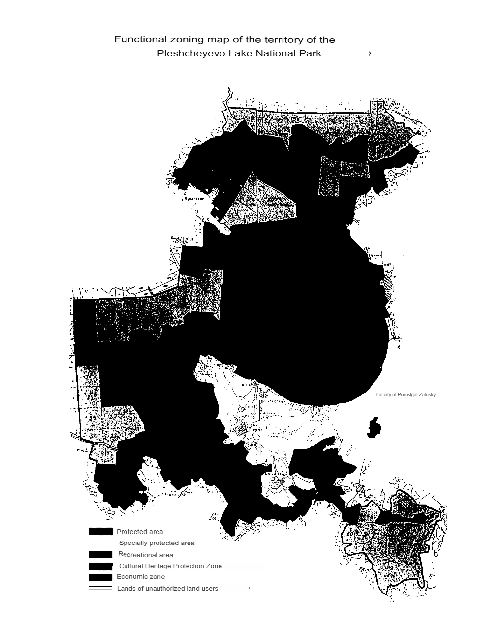
Figure 6 - Functional zoning map of the territory of the Pleshcheyevo Lake National Park
Note: source [32]
Such a scheme is published in the appendix to the Regulations on the FSB Consultant Plus. The lack of legibility of cartographic materials in the official source of legal information leads to delays and errors in determining the functional zoning during land management and construction work
.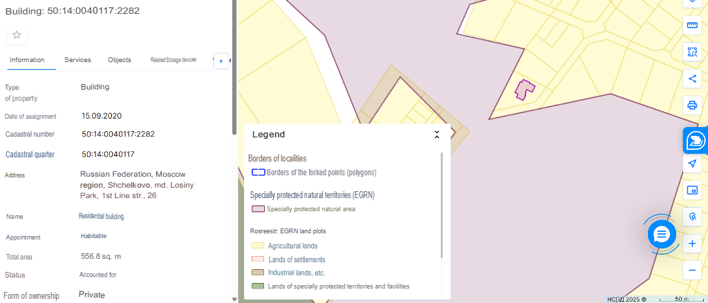
Figure 7 - An example of one of the residential buildings registered in the cadastral register in a 150-meter building-free zone, map scale 1:5000
Note: source [33]
3. Environmental Assessment of the Consequences of Unregulated Development. Spatial analysis allowed identifying potential and actual environmental risks associated with the identified legal and planning dissonances.
Habitat Fragmentation and Biodiversity Loss. Development near PA boundaries and within them (as in the case of the Brusyany cluster) disrupts the integrity of the ecological framework, creating barriers to animal migration and plant dispersal. Plots approved for development often border buffer zones and wetlands.
Impact on Water Resources. Construction in catchment areas (e.g., near Lake Pleshcheyevo) can lead to changes in surface runoff, increased load on water bodies with biogenic elements and pollutants, threatening vulnerable aquatic ecosystems.
Recreational Digression and Soil Degradation. Spontaneous development of individual residential buildings without considering the recreational capacity of territories leads to trampling, soil compaction, and damage to vegetation cover in forest or meadow areas adjacent to houses.
These risks are exacerbated by outdated cadastral maps that do not reflect the actual boundaries of vulnerable ecosystems, allowing economic activity in areas requiring special protection.
4. Discussion
A substantial body of both Russian and international literature offers diverse methodologies for assessing the information The results of the study are consistent with the conclusions of Russian and international works highlighting land management problems within PAs
, . However, this work offers a comprehensive interdisciplinary perspective, linking legal gaps, cadastral errors, and environmental consequences into a single cause-and-effect chain.The key conclusion is that the current regulatory system is reactive rather than preventive. Legal uncertainty and administrative barriers do not so much prevent negative impact as create conditions for "quiet" illegal or semi-legal development, the environmental damage from which manifests later.
International experience (e.g., managing national parks in the USA and Canada) shows the effectiveness of:
1) strict zoning with clear, georeferenced boundaries;
2) mandatory strategic environmental assessment (SEA) for all territorial development plans;
3) the use of public interactive GIS portals to ensure data transparency and public engagement
, .The proposed solution is a transition to "smart" PA land management based on a digital twin of the territory. Such a twin should integrate up-to-date cadastral data, legitimate boundaries and zones, environmental indicators (biodiversity indices, soil condition), and legal norms. This will allow for automated checking of document consistency and modeling the environmental consequences of planned decisions.
International and domestic practice offers many examples of creating databases that allow you to quickly update information and use it to solve emerging problems
.As an example, the geographic information system "State Natural Biosphere Central Forest Reserve"
, , , a review and analysis of the data laid the foundation for further improvement of the database related to specially protected natural areas , .5. Conclusion
The study has revealed systemic shortcomings in regulating land and property relations in the economic zones of national parks, manifesting at three levels:
1. Legal: Inequality of conditions for residents depending on the formal status of settlement boundaries; internal contradictions in subordinate acts; the use of the "silent approval" mechanism, which negates environmental expertise.
2. Information and Technological: Outdated, inaccurate, and poorly readable cartographic materials; lack of integration between cadastral, planning, and environmental data in state information systems.
3. Environmental: Ignoring environmental criteria at the planning stage of development, leading to landscape fragmentation, biodiversity loss, and degradation of natural complexes.
Based on the conducted analysis, the following recommendations are formulated:
1. For Legislative and Executive Authorities:
- Establish a transitional period and a simplified procedure for establishing boundaries of historically formed settlements within PAs to eliminate the legal vacuum.
- Eliminate the practice of "silent approval" for territorial planning documents within PAs. Introduce mandatory, substantive environmental expertise.
- Standardize requirements for cartographic appendices to PA regulatory documents, establishing mandatory standards for accuracy and readability.
2. For PA Management Bodies and Municipalities:
- Develop and implement geodata standards for integrating information from the USRE, NSPD, FGIS TP, and environmental monitoring materials.
- Create public GIS portals for each PA, displaying boundaries, zones, plots, legal regimes, and environmental restrictions online.
- Introduce the practice of strategic environmental assessment (SEA) when making any changes to master plans and LUDR of settlements within PAs.
3. For the Scientific and Professional Community:
- Develop a methodology for quantitative assessment of environmental risks of development within PAs, including calculation of fragmentation and recreational load indicators.
- Actively participate in creating "digital twins" of PAs as a tool for modeling development scenarios and making scientifically based management decisions.
Prospects for further research are seen in testing the proposed "smart management" model on the example of specific national parks, as well as in a comparative analysis of the effectiveness of various legal models for regulating land use in Russian and international PAs.