THE EXPERIENCE OF CREATION OF THEMATIC VECTOR LAYERS OF THE GEOPORTAL OF OMSK SPACE SERVICES CENTER BY MEANS OF COMBINATION OF AERIAL IMAGERY METHODS AND GROUND SURVEY TECHNOLOGIES

Макаренко К.И.
Аспирант,
Омский государственный аграрный университет им. П.А. Столыпина
ОПЫТ СОЗДАНИЯ ТЕМАТИЧЕСКИХ ВЕКТОРНЫХ СЛОЕВ ГЕОПОРТАЛА ОМСКОГО ЦЕНТРА КОСМИЧЕСКИХ УСЛУГ ПРИ ПОМОЩИ КОМБИНАЦИИ МЕТОДОВ АЭРОКОСМИЧЕСКОЙ СЪЕМКИ И ТЕХНОЛОГИЙ НАЗЕМНОЙ СЪЕМКИ
Аннотация
В данной статье рассматриваются основные особенности процесса создания тематического геопортала. Упоминается о производстве векторных карт в Российской Федерации и точности этих карт. Статья предоставляет некоторую информацию об особенностях, преимуществах и недостатках методов аэросъемки и наземной съемки в условиях Омской области. Основная часть статьи посвящена использованию комбинации этих методов в процессе создания геопортала Омского центра космических услуг. Кратко рассмотрена возможность прикрепления тематической информации к объекту на карте. Сообщается о возможности решения некоторых прикладных задач при помощи геопортала. Также, имеется заключение, посвященное некоторым проблемам, возникающим в процессе создания геопортала, и вероятным решениям для их преодоления.
Ключевые слова: геопортал, тематические карты, аэросъемка, наземная съемка, картография.
Makarenko K.I.
Postgraduate student,
Omsk State Agrarian University named after P.A. Stolypin
THE EXPERIENCE OF CREATION OF THEMATIC VECTOR LAYERS OF THE GEOPORTAL OF OMSK SPACE SERVICES CENTER BY MEANS OF COMBINATION OF AERIAL IMAGERY METHODS AND GROUND SURVEY TECHNOLOGIES
Abstract
In the article main features of the process of creation of a thematic geoportal are generally considered. It is told about production of vector maps in Russian Federation and accuracy of these maps. Then, the article provides some information about features, advantages and disadvantages of aerial imagery and ground survey methods under conditions existing in Omsk region. The main part of the article is about opportunities of usage combination of these methods during the process of creation of the Omsk space services center’ geoportal. The possible thematic information attached to objects on maps is briefly reviewed. Then, opportunities of solution some applied tasks by means of the geoportal are reported. Also, there is conclusion about some problems appearing during the process and possible decisions to overcome them.
Keywords: geoportal, thematic maps, aerial imagery, ground survey, cartography.
Introduction
Geoportal is a convenient and functional way of providing of thematic information about objects and area in general. One of tasks of Omsk space services center geoportal [3] is the providing of open cartographic information about the city and the region. The area of OSU and OSAU universities was chosen as the pilot object. Existing maps, aerial imagery and ground survey materials were used for the saving of resources invested. The main advantages of these methods and some problems appearing in the process of its combinations are considered in the article.
Features of the production of vector maps in the Russian Federation
Design of thematic layers may be different depending on specifics of the vector map created. There aren’t any clear requirements even for maps created for the same purposes, therefore similar vector maps for needs of different departments or in different regions of the Russian Federation may differ significantly [1]. As a rule, the problems are not taken into account within matching of them on geoportal.
In addition to the design, there is no single classification system of objects, a set of layers and their display order. There is the problem of using different coordinate systems not only in different regions of the country, but also in the same region. In certain cases, it requires translation of vector map from one coordinate system to another. Working with photoplans created based on aerial and satellite images, allow checking the position of objects after the translation, so it is possible to identify gross errors that may occur in the process of work.
Features of aerial imagery process in the Russian Federation
Almost all the major settlements of the country are located in the more or less flat territory. The territory of Russia is well covered by satellite images. This makes it easy to get the right satellite image and quickly process it for further usage.
There are also quite favorable conditions for aerial photography. With the development of aviation and the appearance of high-precision digital aerial cameras this kind of surveys is gaining popularity year by year. Typically, aerial photography is used to survey cities, villages and large industrial objects. It should be noted, however, that the usage of aerial images, photoplans and large-scale plans that are based on aerial photography is problematic because these materials are often among the secret documents.
The concept of precision for thematic layers of vector map
Vector layer consists of a set of objects and thematic information attached to them. Objects on layer are real objects on the area and they have certain coordinates describing their location, shape and size. These coordinates can be determined with different precision. Since, as mentioned above, in Russia there are no specific guidelines for the creation of thematic maps, it is usually applied to them exactly the same requirements as to the printed product. Position of clear contour point with respect to the nearest NGN (National Geodetic Network) should be determined with an average error of 0.5 mm in the map scale. Besides, many institutions since the days of the Soviet Union practice of using topographic maps as the cartographic basis for thematic maps.
Locating of engineering objects is held in the process of large scale mapping and requires high accuracy, while the accuracy of position of object on the map for agricultural purposes, various reference maps (tourist, economic, land cover map) requirements are significantly lower. On some types of maps defining the boundaries of the object is evaluative in nature (e.g., maps, environmental pollution).
Often cartographic materials to produce thematic maps are taken from different sources. Thus, a part of objects on thematic map may be depicted by means of single source, but another part by using other sources, so, there is necessity of watching at map objects that were drawn from different sources in order to they do not overlap each other and do not leave blank spaces.
We conclude that within production of vector maps it is needed to prioritize: what sources of cartographic information to take some data from. For example, the data about underground utilities may be taken from the tablet, and data about the construction may be obtained using space image.
Advantages and disadvantages of usage of aerial imagery methods
The results of this type of survey can be used to solve various problems of the municipality, business, for improving of the quality of education and health care, monitoring of various processes, using the same photo as a reference map and saving significant financial resources and time. High promptness lets to avoid problems such as, for example, obsolescence of information (at least, geo-information), and also allows easy enough to make changes to the map, if necessary, for example, that could be very important in the preparation of urban planning documentation in never-ending construction in cities.
A significant advantage is sufficiently large coverage area (the larger the area, the more obvious advantages of methods of aerial imagery in comparison with ground survey methods), and in conditions of the Omsk region, which is located on the West Siberian Plain, the distortion from the height of the terrain is minimal, allowing for faster processing of images.
Modern technologies of aviation and the appearance of digital cameras with high resolution provides to get qualitative basis for large-scale maps, but some objects requires to be surveyed by using ground survey methods, because it is impossible for them to get the necessary information when surveying from the air (for example, level of the facades of buildings or objects shut by crowns of trees).
Advantages and disadvantages of usage of ground survey methods
In addition to greater accuracy and the ability to survey impossible for aerial imagery objects, ground survey has no other obvious advantages over aerial imagery, but has several disadvantages, such as higher cost and lower speed of execution. A further disadvantage is the limited visibility of materials, and as result no gross errors are tracked in the drawing contours. However, it is possible to check gross errors from materials of aerial imagery. To demonstrate the inconsistencies in the data opportunities of geoportal can be effectively used.
Practical opportunities of using a combination of methods of aerial imagery and ground survey to create a thematic geoportal (for example, the Omsk space services centre)
Like most geoportals cartographic provision of Omsk space services center geoportal based on the use of satellite images [4]. For this purpose, the pictures of Google, Yandex, as well as Roscosmos satellite imageries are used. By default, these pictures are not precise enough, but they can serve as basis for the production of the majority of vector reference maps.
Fig. 1 shows a fragment of the vector map of the OSAU district containing some general reference information about infrastructure. As a demonstration on the basis of cartographic layers were depicted: Земли СХИ (lands for agricultural uses), Лес (forest), Растительность (vegetation), Водоемы (bodies of water), Кварталы (city blocks), Площади (squares), Улицы (streets), Проезжая часть (carriageway), Здания 1994 (buildings in 1994), Здания 2014 (buildings in 2014). Layer “Здания 1994” (buildings in 1994) was drawn by means of orthophotomap of the area from 1994. Due to the data, we can notice some changes in the development of the territory that have been occurring during the last 20 years [3].

Fig. 1 – A fragment of the vector map OSAU district
To create maps of large scale it is possible to order the actual-time space images having sufficient resolution. Also, aerial and satellite images from other sources and the individual layers obtained by raster tablet scale of 1: 500 in the coordinate system “WGS-84” are used as the cartographic basis. Fig. 2 shows a fragment of the map from Omsk space services center geoportal, combining information about underground communications (were drawn from the tablet), and information about buildings and structures obtained by means of satellite imagery. In addition, layers “Кадастровые кварталы” (cadastral blocks) and “Кадастровые участки” (cadastral parcels) obtained by the public cadastral map exists on this map, so you can immediately notice some serious errors in their allocation (for example, a boundary penetrates through the corner of a building), which may be a reason to clarify the boundaries.
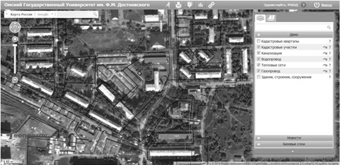
Fig. 2 – A fragment of the vector map with information about underground utilities
Each vector layer on the map corresponds to a table in the database, and each object corresponds to the row in the table. Depending on the type of the object table contains certain fields. Each table contains the fields “Name” and “Code” that makes the identification of the object easier. The tables corresponding to the layers, which depict buildings, usually contain the largest number of fields. These tables contain fields: Building type, Year of construction, Construction material, Street, House number, Floors [3]. Further, any table can be filled with extra-fields (depending on the map use). Thus, even small map can contain a huge amount of diverse information, which is available in readable form.
Geoportals are not just information systems, but also means of various applications. There are geoportals that are used for monitoring of natural phenomena, wildfires, anthropogenic processes, for solving of communal problems, for modeling of urban development and for many other purposes. In the conditions of the city of Omsk it is possible to use Omsk space services center geoportal for solving various problems of urban development activity (the problems of inconsistency of the boundaries of land to the real situation and unauthorized occupation of the territory are very acute for Omsk), problems of interaction of universities and industry (especially that the geoportal were created due to the cooperation of REKOD company and OmSU) [2]. At the moment, the prospects for the development of the geoportal of Omsk center space services are associated with these two directions.
Conclusions
The possibilities of using geoportals as reference and information systems are practically unlimited. Due to the rapid changes in appearance of the city, it is usual when you create a vector map by collecting of the maximum amount of available information, so a problem of accordance of the sources of information appears because they can be quite different in terms of accuracy images of objects, as well as the relevance of the information in time. Usually, problems that may arise are difficult to predict in advance, and therefore it is necessary to solve them in process, that badly affects to the speed of the work. The presence of well-defined requirements for the creation of vector maps, as well as ensuring greater openness of cartographic information could significantly reduce material and labor costs.
Литература
- Алексеев В.Е. Картографическое обеспечение региональных информационно-аналитических систем // Геоматика. – 2011. - № 2. – С. 41-47.
- Компания «РЕКОД» [Электронный ресурс]. – Режим доступа: http://rekod.ru (дата обращения 12.03.2015).
- Омский центр космических услуг [Электронный ресурс]. – Режим доступа: http://omsu.rekod.ru (дата обращения 12.03.2015).
- Центр космических услуг города Одинцово [Электронный ресурс]. – Режим доступа: http://odincovo.rekod.ru/portal (дата обращения 12.03.2015).
References
- Alekseev V.E. Kartograficheskoe obespechenie regional'nyh informacionno-analiticheskih sistem // Geomatika. – 2011. - № 2. – S. 41-47.
- Kompanija «REKOD» [Jelektronnyj resurs]. – Rezhim dostupa: http://rekod.ru (data obrashhenija 12.03.2015).
- Omskij centr kosmicheskih uslug [Jelektronnyj resurs]. – Rezhim dostupa: http://omsu.rekod.ru (data obrashhenija 12.03.2015).
- Centr kosmicheskih uslug goroda Odincovo [Jelektronnyj resurs]. – Rezhim dostupa: http://odincovo.rekod.ru/portal (data obrashhenija 12.03.2015).