ASSESSMENT OF SEISMIC SAFETY FOR CONSTRUCTION SITES OF EARTH DAMS

Серебренников С.П.1, Джурик В.И.2, Брыжак Е.В.3, Ескин А.Ю.4
1ORCID: 0000-0002-6318-042X, кандидат геолого-минералогических наук, 2ORCID: 0000-0002-8082-5461, доктор геолого-минералогических наук, 3ORCID: 0000-0001-7550-4447, кандидат геолого-минералогических наук, 4ORCID: 0000-0002-6956-7692, кандидат геолого-минералогических наук,
1,2,3,4Институт земной коры СО РАН, Иркутск, 3Институт геологии алмаза и благородных металлов СО РАН, Якутск
Исследование выполнено при частичной поддержке Российского научного фонда, исследовательский проект № 15-17-20000
ОЦЕНКА СЕЙСМИЧЕСКОЙ БЕЗОПАСНОСТИ УЧАСТКОВ СТРОИТЕЛЬСТВА ЗЕМЛЯНЫХ ПЛОТИН
Аннотация
В статье реализуется подход, основанный на анализе основных количественных характеристик колебаний грунтов при сильных землетрясениях, необходимых при районировании сейсмической опасности земляных плотин. В методологическом аспекте весь процесс подготовки районирования техногенной и экологической опасности ответственных объектов включает ряд этапов, общий для сооружений, в том числе земляных плотин. Результаты исследований основаны на изучении сейсмической опасности сооружений на территории Монголии, Амурской области и Хабаровского края.
Ключевые слова: сейсмические воздействия, ускорения, землетрясения, сейсмо-грунтовые модели, земляные плотины.
Serebrennikov S.P.1, Dzhurik V.I.2, Bryzhak E.V.3, Eskin A.Yu.4
1ORCID: 0000-0002-6318-042X, PhD in Geology and Mineralogy, 2ORCID: 0000-0002-8082-5461, PhD in Geology and Mineralogy, 3ORCID: 0000-0001-7550-4447, PhD in Geology and Mineralogy, 4ORCID: 0000-0002-6956-7692, PhD in Geology and Mineralogy,
1,2,3,4Institute of the Earth’s Crust SB RAS, Irkutsk, Russia, 3Diamond and Precious Metal Geology Institute SB RAS, Yakutsk, Russia
The study was partially supported by Russian Science Foundation, research project No. 15-17-20000
ASSESSMENT OF SEISMIC SAFETY FOR CONSTRUCTION SITES OF EARTH DAMS
Abstract
In the paper the assessment approach is based on the analysis of main quantitative characteristics of strong ground motions required for the construction of earth dams in seismic zones. In the methodological aspect, the whole process of preparing the zoning of the technogenic and ecological hazard of the responsible facilities includes a number of stages common to the constructions, including earth dams. The results of research are based on seismic hazard assessment for the facilities in Mongolia, Amur Region and Khabarovsk Territory.
Keywords: seismic effects, accelerations, earthquakes, models of seismic ground motions, earth dams.
Itroduction
The paper deals with the analysis of the basic quantitative characteristics of ground motions to determine a hazard potential classification rating for earth dams. The analysis has been made based on the results of the study of seismic hazard of structures in Russia and Mongolia. The objects considered are a part of factors of production in ore mining and processing mills and CHP plants. Methodologically, the entire process of the preparation for hazard potential classification consists of the stages common for earth dams.
Material and methods
Generally, seismic hazard (which implies an assessment of predictive effects of a large earthquake) assessment is based on results of the acoustic (seismic) impedance method. Seismic intensity increment is calculated according to S.V. Medvedev’s formula (1962)[5]:
ΔI=1,67 Lg (pэ Vэ /pi Vi) (1),
where pэVэ and piVi are the values of acoustic impedance of the reference and investigated grounds for longitudinal (Vp) or transverse (Vs) waves, and DI are the estimated intensity increments.
The authors’ proposed correction is implemented in Equation (2) for loose, water-saturated sediments with regard to the depth to the water-table (h):
![]() (2)
(2)
Coefficient R is set equal to 1 for the areas dominated by sandy and clayey sediments and to 0.5 for those dominated by coarse and gravel-and-pebble deposits. Correction DIУГВ is not implemented at the depth to the water-table less than 7-10 m. In this case, the increments calculations according to Formula (1) involve the longitudinal wave velocities in air-dry soils that are of the same composition as water-saturated layers.
Therefore, making seismic hazard assessment based on results of the acoustic (seismic) impedance method and generating seismic models to implement calculation methods, the authors used the necessary background information on composition, reference and investigated bulk densities, including saturated unit weight, and their related seismic wave propagation velocities.
The first stage involved the analysis and collection of seismic data. The data analysis allowed us to consider the ranges of variation of parameters of source zones of large earthquakes in the area of existing, upgraded and projected earth dams. They are: epicentral distance 0-100 km, magnitude 6.0-7.9, intensity up to 8, focal depth 15-20 km, focal mechanism – strike-slip and reverse-slip earthquakes [8], [2], [4].
The second stage is technological and most informative in a hazard potential classification rating process for the investigated dams (Fig.1,2). This step involves conducting instrumental studies:
- Study of seismic properties of the rocks of basic types.
- Selection and substantiation of reference ground parameters.
- Seismic hazard zoning by the acoustic (seismic) impedance
Shallow seismic sounding methods used in the dam operation and construction areas are proven and published [1], [3], [10], [11], [12].
Sounding sites were chosen with due regard to the uniform coverage of typical ground conditions in location of a certain object under investigation. In all, we performed and analyzed more than 400 soundings. The dam parts differ in their engineering-geological and hydrogeological conditions, which are reflected in the pattern of waves on the seismograms recorded.
Results
The seismogram interpretation allowed us to measure seismic wave velocities. To solve the tasks posed, the article involves the velocities of longitudinal and transverse waves. The velocities of transverse waves were used to generate models of seismic ground motions that are required to implement calculation methods. The longitudinal wave velocities are used as a basis for the study of the effects of an earthquake on the ground. The analysis of seismic wave velocities confirms a wide range of their variation in loose sediment from abnormally low values of 280-500 m/s (in a 3-m layer) to 600-800 m/s and higher velocities underneath. The velocities on the dam sides can be 2000 m/s and higher, which is due to the presence of disintegrated and relatively intact rocks even if they are shallow. The results of velocity measurements in certain sounding sites are tabulated or displayed in the histograms for air-dried and water-saturated rock or loose sediment.
Loose air-dry sediments were combined in one group irrespective of their composition, their wave velocities ranging from 500 to 1200 m/s. Loose sediment thickness can vary from 5-10 to more than 30 m. Maximum velocity distribution falls within seismic velocity intervals of 600-700 and 1000-1100 m/s, which implies the existence of two distributions. The first of them corresponds to loose sediments dominated by relatively small fraction, and the second can be assigned to coarsely clastic and disintegrated rocks. The minimum values (Vp) are typical of seasonal earth freezing and mainly fall within the range of 300 to 400 m/s. According to the existing normative documents, the grounds no more than 10 thick, corresponding to the first distribution, are considered average in accordance with their seismic properties (category II), and their seismic hazard will correspond to the initial one.
The longitudinal wave velocities in water-saturated loose sediments can be 2-5 times higher than those in air-dry sediments, and Vp values are consequently within the range of 1500 to 2300 m/s. Most of the water-bearing loose sediments are assigned to category III in accordance with their seismic properties, and their seismic hazard can be one unit higher than that of the average soils. Depending on the degree of rock disintegration, the P-wave velocities vary from 700 m/s in marls to 2000 m/s in severely disintegrated rocks, and from 2000 to 4000 m/s in only slightly disintegrated rocks. The velocity in disintegrated to slightly fractured rocks on the investigated dams varies within the range of 1200 to 3600 m/s. There occurs a distribution of two maximums of Vp equal to 2400 and 3000 m/s. According to seismic properties, these grounds are category I, with seismic hazard usually supposed to be one unit lower than the initial one. In our case, the velocity values presented above are accepted reference values for all structures of this type.
Discussion
Therefore, the calculations of seismic hazard and use of computational methods on the earth dam parts involved the analysis of all necessary data on composition of the ground, seismic wave propagation velocities, depth of groundwater occurrence, and loose sediment thickness.
Mapping and assessment of seismic risk for a certain structure implies that an earthquake whose intensity will exceed the shown (predicted) value can occur therein during a certain period of time (50 or 100 years) [9]. In earthquake engineering, the motion intensity is characterized by the effective peak ground acceleration. This predicted maximum acceleration is assessed for certain parts of the dams represented in seismic models. Since this value is calculated for an event having a certain probability of occurrence, it implies an uncertainty in earthquake damage prediction for the investigated area [13]. This stage involved calculation of basic characteristics of seismic intensity – accelerograms, spectral characteristics and acceleration spectra, –which are necessary to generate prediction models and initial signal. The initial signal of a probable serious earthquake is determined from the quantitative geological-geophysical and seismological data. The predicted model is generated from direct measurements of seismic wave velocities on the earth dams.
Obtaining the main characteristics, directly used in the study of earthquake-resistant constructions, requires assigning computational models. Model generation involves the engineering-geological data and results of the measurements we made at certain objects. The models were generated in the amount which entirely covers probable variations in composition, condition and thickness of loose deposits and in seismic wave velocities with depths. The models are characterized by thickness of loose deposits, wave propagation velocities, and rock density.
Each model involves computation of the characteristics required and representation of proper accelerograms, spectra, and frequency characteristics. One of the models is exemplified on Figure 1.
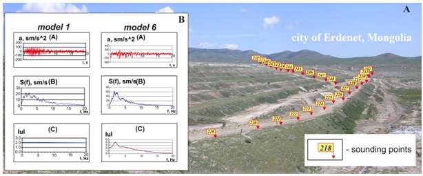
Fig. 1 – Presents the schematic map showing areas covered by seismic sounding studies (A) and basic types of models that most accurately represent the main engineering-seismological characteristics of the construction (В)
This work has resulted in earth dam models based on the increment of seismic intensity from 0 to 2 units relative to rock reference materials (table 1).
Considering large earthquake parameters and ranges of their variation for the investigated objects, we have synthesized an initial accelerogram for horizontal (EW) component [6].
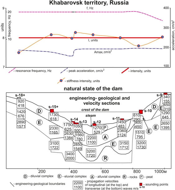
Fig.2 – Engineering and seismological conditions of the tailings dam construction for natural grounds
The accelerogram was normalized to rock foundation and has the following basic parameters: maximum acceleration 58 cm/s2, maximum spectrum value 10 cm/s, spectrum frequency range at a level of 0.7 of the maximum varying from 1 to 5 Hz, duration of motions at a level of 0.3 of the maximum being 20 s [7].
Rock-level peak horizontal acceleration does not exceed 110 cm/s2. In accordance with the intensity scale, this corresponds to reference earthquake effect on the rocks in the area equal to 7 units. Acceleration spectrum has its peak value (at a level of 0.5) in the frequency range from 1 to 5.5 Hz. The main peaks account for frequencies of 1.5 and 2.5 Hz, the spectral density values thereon are 22; 23 cm/s for EW component.
Table 1 – The parameters calculation of seismic models for generalized model cuts
| № model, model cut | h(m) | Vp(m/s) | Vs(m/s) | r(t/m3) | ∆I |
| №1, Rocky soils (standard) | 10 | 2400 3000 | 1300 1600 | 2,5 2,6 | 0 |
| Looseair-drysediments | |||||
| №2 Bacterial fertilizers | 5 40 | 500 2700 | 250 1600 | 1,8 2,6 | +0,96 |
| №3 Loams, Sands | 5 40 | 600 2800 | 300 1600 | 1,9 2,6 | +1,26 |
| №4 Loam, bacterial fertilizers | 5 40 | 600-700 3000 | 250 1600 | 1,8 2,6 | +1,11 |
| №5 Sand, loam, gravel, boulders | 10 40 | 700-800 3000 | 350-400 1500 | 1,9-2,0 2,5-2,6 | +1,1 |
| №6 boulders, sand, loam. | 10 20 40 | 700 800-900 2400-3000 | 350 400 1300-1600 | 1,8 1,9 2,5-2,6 | +1,1 |
| №7, medium soils (standard) | 10 40 | 720 2400-3000 | 360 1300-1600 | 1,9 2,5-2,6 | +1,0 |
| Water-saturated loose sediments | |||||
| №8 Friable, GWL with 5 m | 5 10 | 1600 2400-3000 | 380 1300-1600 | 2,0 2,5-2,6 | +1,36 |
| №9 Friable, GWL with3 m | 3 7 10 | 720 1600 2400-3000 | 360 380 1300-1600 | 1,8 2,0 2,5-2,6 | +1,69 |
| №10 mediumsoils (water-saturated) | 10 40 | 1700 2400-3000 | 420 1300-1600 | 2,0 2,5-2,6 | +2,00 |
Conclusion
The extent of work done allowed the authors to develop a geophysical technique to determine a hazard potential classification rating for earth dams that might be unsafe during earthquakes and thus exert influence on existing and projected plant production process and ecological situation of adjacent areas.
Список литературы / References
- Джурик В.И. Методика районирования параметров сейсмической опасности линейных сооружений по сейсмогрунтовым моделям / В.И. Джурик, С.П. Серебренников, А.Ф. Дреннов, Л.А. Усынин // Криосфера земли. – 2008. – Т. XII, №4. – С. 66-76.
- Джурик В.И. Сейсмичность и районирование сейсмической опасности территории Монголии / В.И. Джурик, А.В. Ключевский, С.П. Серебренников и др.; отв. ред. Ф.И. Иванов. – Иркутск, ИЗК СО РАН, 2009. – 420 с.
- Джурик В.И. Динамика физического состояния ослабленных зон насыпной плотины Иркутской ГЭС за период 2002–2012 гг. / В.И. Джурик, А.Ю. Ескин, С.П. Серебренников, Е.В. Брыжак // Известия Иркутского государственного университета. Серия «Науки о Земле». – 2014. – Т.8. – С. 35–41.
- Имаева Л.П. Карта сейсмотектоники Восточной Сибири / Л.П. Имаева, В.С. Имаев, О.П. Смекалин и др. – Иркутск-Нерюнгри, ИЗК СО РАН, 2015. – 127 с.
- Медведев С.В. Инженерная сейсмология / С.В. Медведев. – Москва, Госстройиздат, 1962. – 260 с.
- Aki K. Scaling law of seismic spectrum / K. Aki // Journal of Geophysical Research. – 1967. – Vol. 72. – P. 1217-1231.
- Anderson J.G. A model for the shape of the Fourier amplitude spectrum of acceleration at high frequencies / J.G. Anderson, S.E. Hough// Bulletin of the Seismological Society of America. –1984. – Vol. 74. – P. 1969-1993.
- Brune J.N. Tectonic stress and the spectra of seismic shear waves from earthquakes/ J.N. Brune // Journal of Geophysical Research. – 1970. – Vol. 75. – P. 4997-5009.
- Complex geophysical and seismological investigations in Mongolia / Editors in chief: V.I. Dzhurik, T. Dugarmaa. – Ulanbaatar-Irkutsk, 2004. – 315 p.
- Dzhurik V.I. The technique of seismic risk mapping for the territories of economic development of Mongolia / V.I. Dzhurik, T. Dugarmaa, Ts. Batsaikhan, S.P. Serebrennikov, Drennov A.F. // Proceedings of Mongolian Academy of Sciences. – 2004. – P. 16-29.
- Dzhurik V.I. Technique and experience of seismic zoning of the cities of Ulaanbaatar and Erdenet / V.I. Dzhurik, Ts. Batsaikhan, S.P. Serebrennikov and others // Proceedings of the Mongolian Academy of Sciences. – 2014. – No 4. – P. 51–58.
- Serebrennikov S.P., Dzhurik V.I., Batsaikhan Ts., Yushkin V.I., Drennov A.F., Eskin A.Yu., Baskakov V.S. Solving problems of balneology in the practice of hydrogeology and seismology by using shallow-depth geophysics / S.P. Serebrennikov, V.I. Dzhurik, Ts. Batsaikhan, V.I. Yushkin, A.F. Drennov, A.Yu. Eskin, V.S. Baskakov. – Recent geodynamics and natural hazards in the Central Asia. Issue 4. Transactions of the VI Russian-Mongolian Conference on Astronomy and Geophysics, 2006. – IEC SB RAS, Irkutsk. – P. 39-43.
- Watanade K. Integral transform techniques for Green’s function / K. Watanade. – Cham ZG, Switzerland: Springer International Publishing AG, 2014. – 190p.
Список литературы на английском языке / References in English
- Dzhurik V.I. Metodika rajonirovanija parametrov sejsmicheskoj opasnosti linejnyh sooruzhenij po sejsmogruntovym modeljam [Methods of classification of parameters of seismic hazard of linear structures by seismic ground models] / V.I. Dzhurik, S.P. Serebrennikov, A.F. Drennov, L.A. Usynin // Kriosfera zemli [Earth Cryosphere]. – 2008. – T. XII, №4. – P. 66-76. [in Russian]
- Dzhurik V.I. Sejsmichnost' i rajonirovanie sejsmicheskoj opasnosti territorii Mongolii [Seismicity and zoning of seismic hazard of the territory of Mongolia] / V.I. Dzhurik, A.V. Kljuchevskij, S.P. Serebrennikov and others; edited by F.I. Ivanov. – Irkutsk, IZK SO RAN, 2009. – 420 p. [in Russian]
- Dzhurik V.I. Dinamika fizicheskogo sostojanija oslablennyh zon nasypnoj plotiny Irkutskoj GJeS za period 2002–2012 gg. [Dynamics of the physical state of the weakened zones of the bulk dam of the Irkutsk HPP for the period 2002-2012] / V.I. Dzhurik, A.Ju. Eskin, S.P. Serebrennikov, E.V. Bryzhak // Izvestija Irkutskogo gosudarstvennogo universiteta. Serija «Nauki o Zemle» [The bulletin of Irkutsk state university. Series «Earth Sciences»]. – 2014. – Vol. 8. – P. 35–41. [in Russian]
- Imaeva L.P. Karta sejsmotektoniki Vostochnoj Sibiri [Map of seismotectonics of Eastern Siberia] / L.P. Imaeva, V.S. Imaev, O.P. Smekalin and others. – Irkutsk-Nerjungri, IZK SO RAN, 2015. – 127 p. [in Russian]
- Medvedev S.V. Inzhenernaja sejsmologija [Engeneering seismology] / S.V. Medvedev. – Moskva, Gosstrojizdat, 1962. – 260 p. [in Russian].
- Aki K. Scaling law of seismic spectrum / K. Aki // Journal of Geophysical Research. – 1967. – Vol. 72. – P. 1217-1231.
- Anderson J.G. A model for the shape of the Fourier amplitude spectrum of acceleration at high frequencies / J.G. Anderson, S.E. Hough// Bulletin of the Seismological Society of America. –1984. – Vol. 74. – P. 1969-1993.
- Brune J.N. Tectonic stress and the spectra of seismic shear waves from earthquakes/ J.N. Brune // Journal of Geophysical Research. – 1970. – Vol. 75. – P. 4997-5009.
- Complex geophysical and seismological investigations in Mongolia / Editors in chief: V.I. Dzhurik, T. Dugarmaa. – Ulanbaatar-Irkutsk, 2004. – 315 p.
- Dzhurik V.I. The technique of seismic risk mapping for the territories of economic development of Mongolia / V.I. Dzhurik, T. Dugarmaa, Ts. Batsaikhan, S.P. Serebrennikov, Drennov A.F. // Proceedings of Mongolian Academy of Sciences. – 2004. – P. 16-29.
- Dzhurik V.I. Technique and experience of seismic zoning of the cities of Ulaanbaatar and Erdenet / V.I. Dzhurik, Ts. Batsaikhan, S.P. Serebrennikov and others // Proceedings of the Mongolian Academy of Sciences. – 2014. – No 4. – P. 51–58.
- Serebrennikov S.P., Dzhurik V.I., Batsaikhan Ts., Yushkin V.I., Drennov A.F., Eskin A.Yu., Baskakov V.S. Solving problems of balneology in the practice of hydrogeology and seismology by using shallow-depth geophysics / S.P. Serebrennikov, V.I. Dzhurik, Ts. Batsaikhan, V.I. Yushkin, A.F. Drennov, A.Yu. Eskin, V.S. Baskakov. – Recent geodynamics and natural hazards in the Central Asia. Issue 4. Transactions of the VI Russian-Mongolian Conference on Astronomy and Geophysics, 2006. – IEC SB RAS, Irkutsk. – P. 39-43.
- Watanade K. Integral transform techniques for Green’s function / K. Watanade. – Cham ZG, Switzerland: Springer International Publishing AG, 2014. – 190p.