Modern geodynamic movements of Kuzbass caused by technogenic seismicity
Modern geodynamic movements of Kuzbass caused by technogenic seismicity
Abstract
The article presents the methodology and results of an experimental study of current geodynamic movements of the mining territory of the Kuznetsk coal basin, characterized by unprecedented volumes of minerals extracted from the subsoil, which leads to the manifestation of seismic activity caused by the manmade influence of mining facilities.
The methodology of instrumental studies of post-seismic shifts and deformations of a technogenically altered rock mass on large spatial and temporal bases is presented, including both the determination of daily amplitudes of coordinate changes along three coordinate axes — amplitude and trend components before, between series and after techno-genic seismic events, and the distribution of horizontal shifts and deformations of a rock mass by comparing cyclic coordinates, obtained as a result of equalization of the geodetic GNSS network.
An increase in the values of tensile displacements and deformations of the massif in the latitudinal direction was recorded, along the prevailing submeridional tectonic faults of the region, while no deformation evidence of the preparation of a seismic event was found. A vector field of displacements and a tensor field of deformations were constructed, according to the nature of the distribution of which in the area of the Kyrgai seismic event, tensile deformations in the submeridional direction were recorded, which indicates the predominant implementation of movements along active tectonic faults of the submeridional direction.
1. Introduction
In connection with the development of natural-technical systems and the increasing complexity of mining and geological conditions for the development of mineral deposits, there is a need to assess the degree of protection of mining areas and forecast hazardous processes in subsoil use based on geoinformation and geodeformation (geomechanical) monitoring data with an assessment of the state of mining enterprises and mining areas as natural-technical systems.
One of the research methods in this area is filling, analyzing and structuring a database of modern geodynamic movements and deformations in a mining area where a technogenic earthquake occurred, the deformation pattern of which can be constructed using geodeformation methods that allow determining the parameters of modern geodynamic movements and their derivatives, such as the tensor field of deformations, divergence and field rotor.
The Kuznetsk coal basin area, which is characterized by unprecedented volumes of minerals extracted from the subsoil, was chosen as the object of research. In total, over the years of intensive development of this unique and richest region of Siberia, coal production amounted to, according to various estimates, 13–15 billion tons , , in addition, in Kuzbass, up to 400 million m3 of rock mass is extracted from the natural geological environment, moved and stored on the earth's surface every year. The movement of large volumes of natural resources over the past decades changes the geological environment of the region, disrupts the stability and equilibrium state of its subsoil. In the work , it was established that the long-term impact of mining operations on the largest seismogenic structures of the Altai-Sayan seismically active region initiates their manifestations around industrial zones, increases the background seismicity of the subsoil as a response to large-scale manmade processes occurring in Kuzbass.
2. Kuzbass technogenic seismicity
The largest seismic events recorded in Kuzbass in the 20th century, during the period of active growth in coal mining volumes, as well as the nature of the spatial grouping of sources around the largest industrial centers of the basin, confirm the manmade impact of mining facilities on the manifestation of seismic activity in the region.
Increased seismic activity in areas of intensive mineral development in Kuzbass has been repeatedly noted in reports by the Federal Research Center "Unified Geophysical Service of the Russian Academy of Sciences" , , . By analyzing seismic event recurrence graphs, their distribution over time during the work week and the location of epicenters, it was established that seismicity in Kuzbass has been of a complex natural and man-made nature since the 1960s. Since the late 1980s, natural and technogenic seismicity has entered a stage characterized by swarm stream manifestations of seismic events of low-energy class and powerful shallow earthquakes in areas of high concentration of mining operations, primarily near deep quarries .
The most striking event of this type was the earthquake of June 19, 2013 with a magnitude of M = 5.2 near the Bachatsky open pit. It was established that natural and technogenic activity is largely associated with deep faults, relatively weakly manifested in the upper layer of the earth's crust and the terrain, which indicates the acceleration of their germination to the surface under the influence of man-made factors. After the Bachatsky technogenic earthquake, much attention was paid to the development of a network of seismic stations in Kuzbass, which makes it possible to record not only large seismic events, but also medium and small energy events. By 2015, the network was supplemented with new seismic stations , . In subsequent years, continuous monitoring and recording of seismic events in Kuzbass was carried out, including those associated with natural seismic activity in the region and large-scale mining operations , .
Currently, continuous seismological monitoring is conducted in the region to study the natural and technogenic seismicity of Kuzbass, Gornaya Shoria and the entire Altai-Sayan region. This has led to the development of a multi-level network of seismic stations in the region, including international, regional and local telemetry (Fig. 1), the results of which allow for a high degree of accuracy in recording the location, depth, and magnitude of natural and man-made seismic events, as well as, at the level of mining enterprises — the level of local seismic monitoring, recording low-energy events, mainly for the purpose of preventing rock bursts and monitoring rock movement and quarry wall stability, i.e., at local large-scale levels.
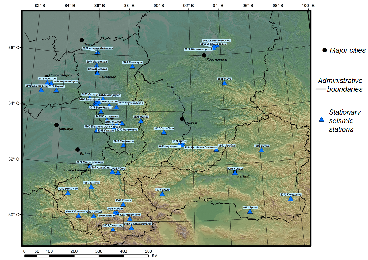
Figure 1 - Current state of the Altai-Sayan network of seismic stations
Unfortunately, there are no actual data on modern geodynamic movements of the upper part of the earth's crust for the territory of Kuzbass, since geodetic (traditional and GNSS monitoring) stations appeared much later, their placement density was low, and their remoteness was large. Nevertheless, a number of researchers have preliminarily worked out the issue of assessing the magnitudes and speeds of modern geodynamic movements based on instrumental mine surveying and geodetic measurements , , , .
3. Research methodology
In August 2021, a fairly large technogenic earthquake was recorded in Kuzbass , , . A seismic event with a magnitude of M = 4.9 occurred on 12.08.2021 near the settlement of Kyrgai, where open-pit coal mining is carried out, dumps are located (Fig. 2).
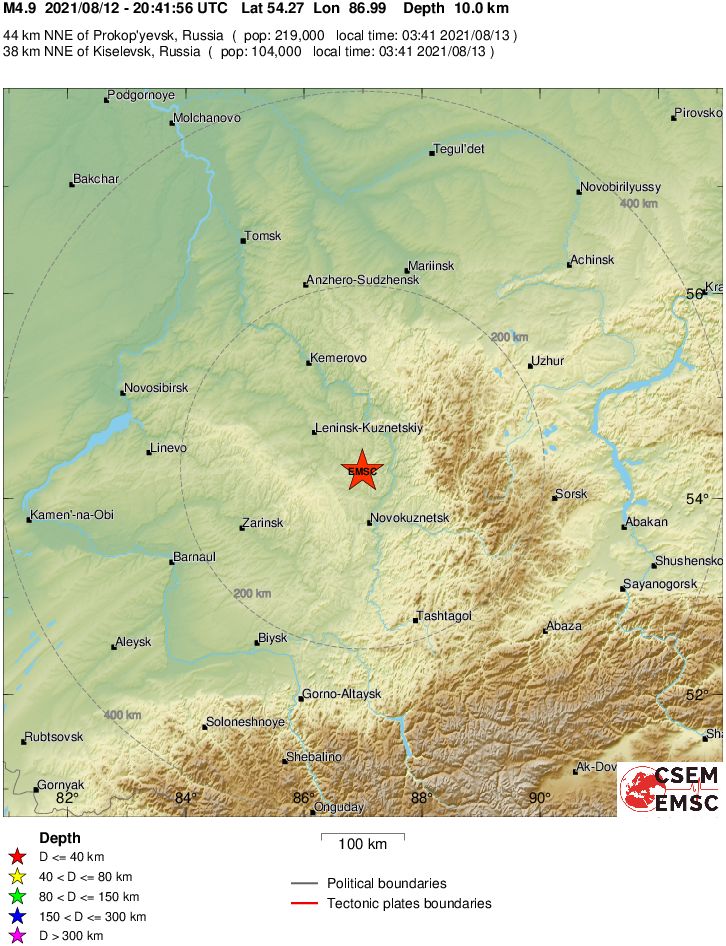
Figure 2 - Location of the epicenter of the seismic event in the area of the settlement of Kyrgai
On the specified date, in the area of the seismic event, in addition to seismological monitoring data, data from permanent GNSS stations in the region are available, which make it possible to obtain information about the stress-strain state of the massif — before the seismic event, during it, and after the seismic event.
To study post-seismic deformations of a rock mass on large spatio-temporal bases, a methodological approach is proposed, used in diagnosing changes in the stress-strain state of the massif during the earthquake in the Katav-Ivanovsk region in September 2018. The initial data were obtained as a result of a study of regional geodynamics using the initial data of permanent stations of the Global Navigation Satellite System (GNSS) of the Urals , .
In connection with the technogenic earthquake that occurred on 12.08.2021, an experiment was conducted to diagnose changes in the stress-strain state of the rock mass in the area of the settlement of Kyrgay. The dimensions of the study area are 150 × 150 km (Fig. 3). The experiment involved 9 permanent GNSS stations in the specified area, using the data accumulated by the stations in the RINEX format. Office processing is carried out in the Bernese Software (using the Precise Point Positioning PPP method) and Waypoint GrafNet (using the Double Difference DD method) software packages, with the determination of the spatial coordinates of the points for each daily series. A selection of initial data was made for the period from 30.07.2021 to 15.02.2022 to record movements and deformations before, during and after the earthquake.

Figure 3 - Layout of GNSS network points for motion and deformation research
Note: arrows indicate the largest mining regions
- determination of absolute coordinates of points and their changes along the coordinate axes daily, for the period from 07.07.2021 to 18.09.2021, by linking them from 10-12 IGS reference points in the INRF-2014 system;
- processing and adjustment of the GNSS network to study trend movements by comparing the spatial coordinates of points obtained in various series of monitoring measurements.
The experiment program allows us to determine the numerical values of:
- daily amplitudes of coordinate changes along three coordinate axes, the amplitude and trend components before the earthquake, between series of earthquakes and after the earthquake;
- distribution of horizontal displacements and deformations of the rock mass by comparing the cyclic coordinates obtained as a result of adjusting the geodetic network.
4. Research results
At the first stage, using the AUSPOS service, daily time series were constructed for the period from 07.07.2021 to 18.09.2021 (for the period before and after the technogenic earthquake in the settlement of Kyrgai. Based on the fact that the earthquake was shallow-focus, observation points were selected to construct time series of displacements that met the condition: nearby and functioning during this period (Fig. 4).
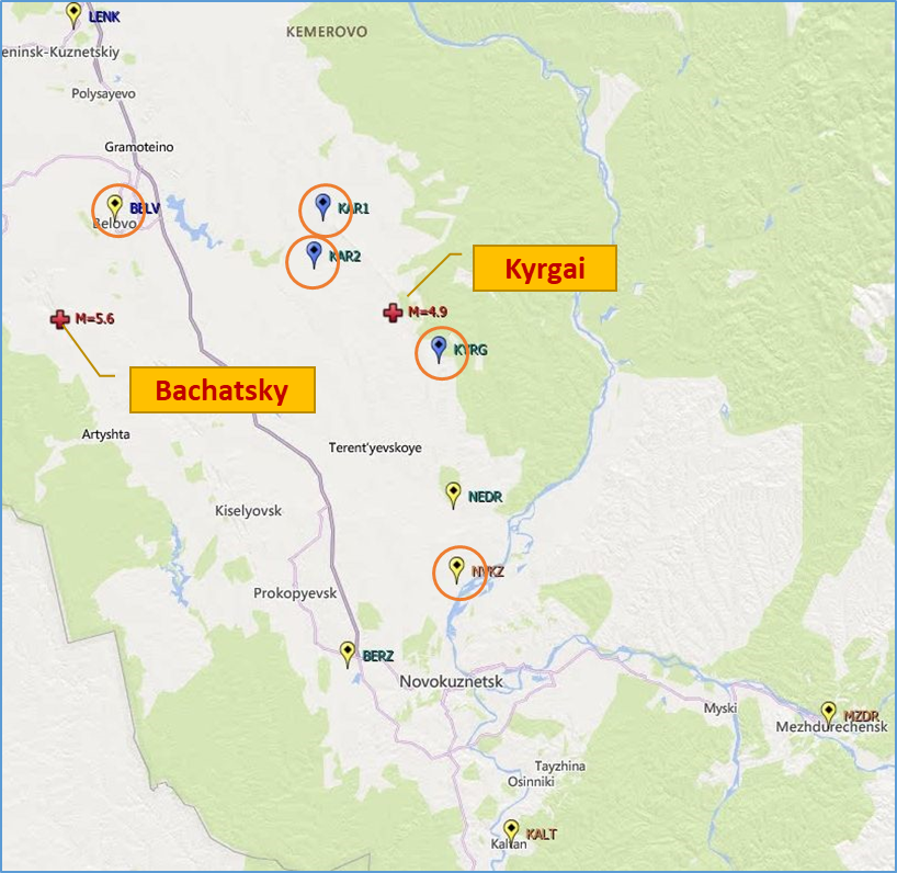
Figure 4 - Layout of observation points for constructing time series of movements
When analyzing the obtained time series (Fig. 5) the following conclusions were made:
- no evidence of preparation for a seismic event was found, the left parts of the graphs (before the seismic event) do not show an anomalous nature of the distribution of displacements by latitude (Fig. 5a) and longitude (Fig. 5b);
- a "stretching" of the massif in the meridional direction after a man-made earthquake was recorded. The points "run away" in latitude, most likely this is due to the prevailing submeridional extension of the main tectonic faults;
- in longitude, most of the observation points maintain the trend component (for Kuzbass it is approximately 26.5 mm/year), one of the points (Karakan-2) does not.
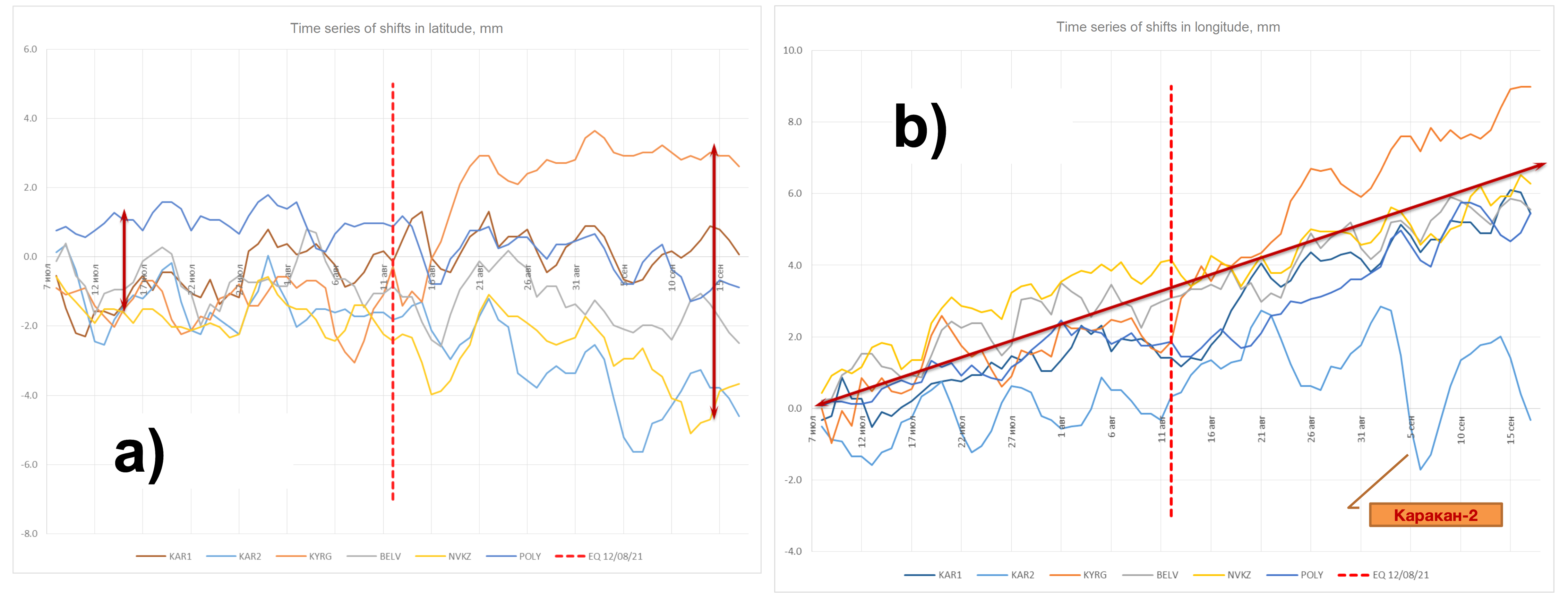
Figure 5 - Time series of shifts:
а – in latitude; b – in longitude
At the second stage, in order to clarify the distribution pattern of horizontal displacements and deformations of the rock mass, based on the results of processing and adjustment of the geodetic GNSS network, cyclic spatial coordinates of observation points were obtained.
For correct comparison of cyclic coordinates when processing a geodetic network, it is necessary to form an "equilibrium system". This is due to the fact that it is not always possible to select a "conditionally fixed" point , , the fixed values of whose spatial coordinates are used to center the geodetic network. In addition, for the conditions of Kuzbass, it has been experimentally established that modern geodynamic movements in the latitudinal direction have significant variability, possibly associated with the seasonal component, or with the presence of a large number of active tectonic faults of the submeridional direction in the studied territory, along which creep movements occur.
Based on the results of processing the geodetic GNSS network covering the area of the Bachatsky (18.06.2013) and Kyrgay (12.08.2021) technogenic earthquakes (before and one year after the seismic event), a vector field of displacements and a tensor field of deformations were constructed (Fig. 6).
In the area of the Kyrgay seismic event, "stretching" deformations in the submeridional direction were recorded, which indicates the predominant implementation of movements along active tectonic faults of the submeridional direction.
The above data on the distribution of the magnitudes and directions of horizontal displacement vectors and horizontal (shear) deformation tensors in the area of the Bachatsky and Kyrgay technogenic earthquakes are preliminary and are subject to further clarification.
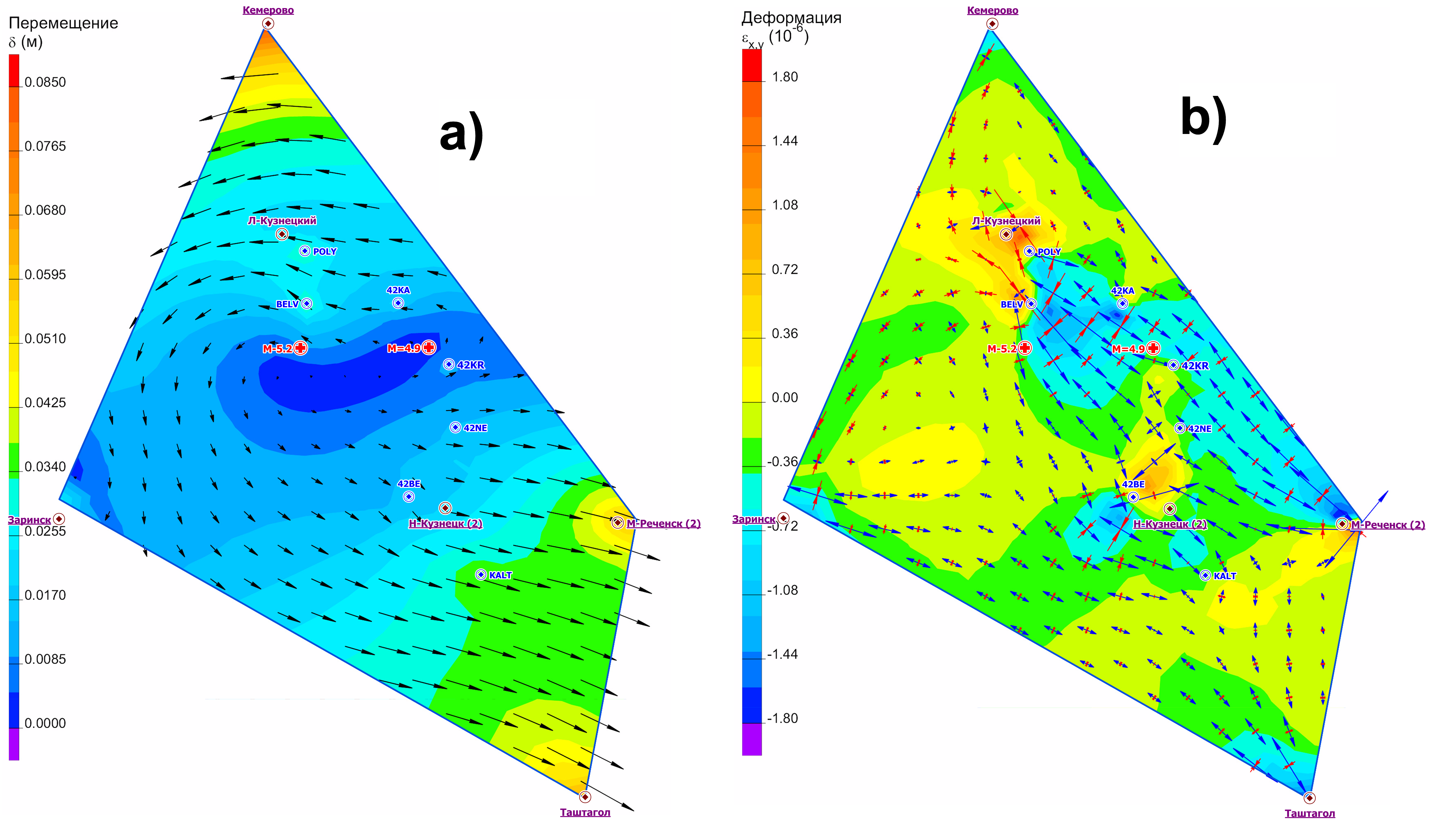
Figure 6 - Vectors in the area of the Bachatsky and Kyrgaysky technogenic earthquakes for the period 2021-2022:
а – of horizontal displacements; b – and tensors of horizontal (shear) deformations
It was shown in that, in order to determine a stable trend in the spatial and temporal distribution of modern geodynamic movements at small bases, it is necessary to conduct instrumental geodetic observations at GNSS points for at least 2 years. In this regard, in 2024–2005, the database "Modern geodynamic movements of the territory of Kuzbass and Altai" was significantly updated with both new series of measurements and new observation posts. An assessment of the stability of a number of points in latitude and longitude was also carried out, while the seasonal component of latitude shifts was recorded, which must be taken into account during long-term monitoring , and instrumental measurements should be planned for August-September, when the rock mass is least susceptible to deformations caused by temperature effects (Fig. 7).
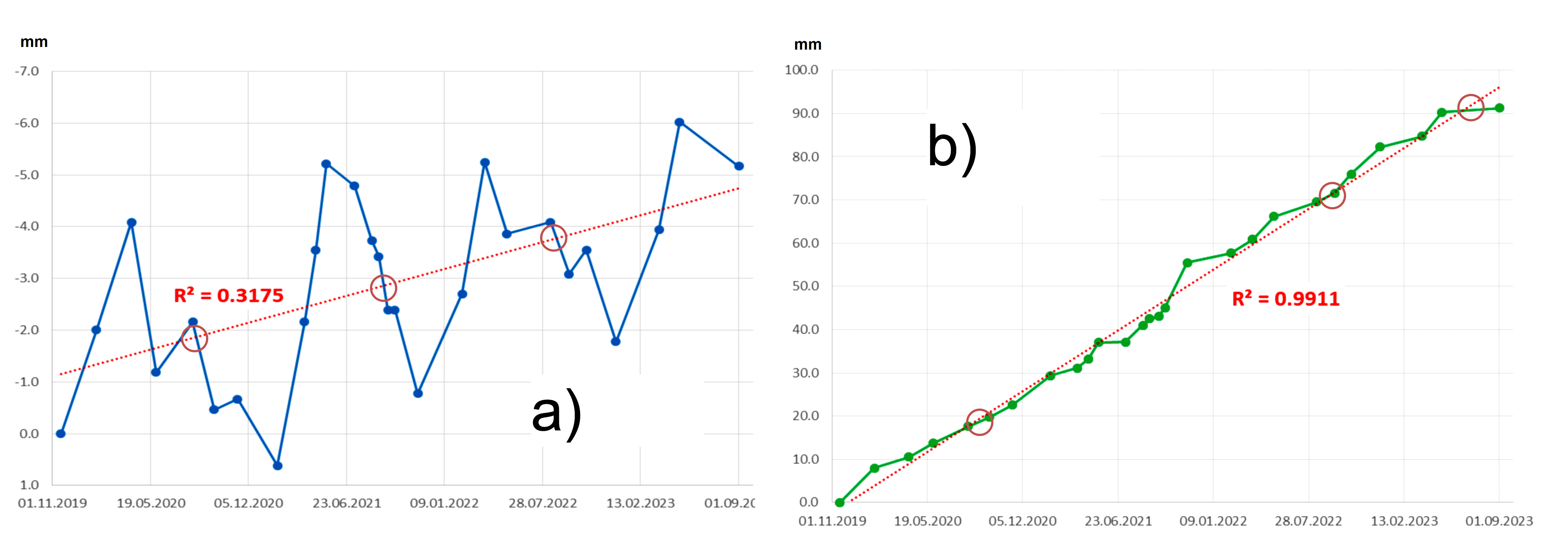
Figure 7 - Long-term movements of the Karakan-2 observation point:
а – latitude; b – longitude
The different character of the time series of displacements of points and the amplitudes of displacements in latitude and longitude may be due to the physico-mechanical properties of the rock mass, since coal deposits are confined to the sedimentary stratum, and iron ore deposits are confined to the rocky massif. An additional, and possibly decisive, factor is the technology and depth of mining operations: coal deposits with man-made seismicity (Bachatskoye, Kyrgyzayskoye, Kolyvanskoye) are developed in an open-pit manner, and the sections are long and shallow. The iron ore deposits: Tashtagolskoye (24.07.2024, M = 4.6), Sheregeshskoye (19.09.2024 M = 4.6) are developed underground, the depth of the mines exceeds the depth of the sections by 2–3 times.
In this regard, to study modern geodynamic movements and deformations, including those manifested in a dynamic form, a method of geodeformation analysis of a mining area is proposed. When performing research, the parameters of modern geodynamic movements and their derivatives are determined both on large spatial and temporal bases at the level of the mining region (background), the level of the deposit and its constituent massif (man-made), and at short intervals (instrument array, displacement trough), including if there are closely located (up to 5 km) of observation GNSS points, the amplitudes and frequencies of cyclic short-period shifts are determined using instrumental methods in order to identify active tectonic structures.
5. Conclusion
Based on the results of the study of natural and technogenic seismicity, as well as replenishment of the database of modern geodynamic movements of the mining areas of Kuzbass and Altai, daily time series of displacements were constructed in the period before and after the shallow-focus technogenic earthquake in the settlement of Kyrgay (12.08.2021, M = 4.9). An increase in the values of tensile displacements and deformations of the massif in the latitudinal direction was recorded, along the predominant submeridional tectonic faults of the area, while no deformation evidence of the preparation of a seismic event was found. A vector field of displacements and a tensor field of deformations were constructed, according to the nature of the distribution of which in the area of the Kyrgay seismic event, "extension" deformations in the submeridional direction were recorded, which indicates the predominant implementation of movements along active tectonic faults of the submeridional direction.
Further studies of natural and technogenic seismicity of the Kuznetsk coal basin are planned to be carried out in the area of the Kolyvansky coal mine, where an industrial explosion was carried out on 27.11.2023, and two seconds after the explosion, a major seismic event with a magnitude of M = 4.7 occurred in the same area. The course of the seismic process in previous years and the location of this and other earthquakes in this area, as well as the proximity of events to the surface, indicate the man-made nature of the entire activation and this earthquake in particular. At the same time, the technogenic earthquake of 27.11.2023 is the largest in energy in the entire series of events that were observed in the area of the Gorlovsky coal trough.