Wetlands and Climate Change: a Global Concern
Wetlands and Climate Change: a Global Concern
Abstract
One of the most urgent topics and at the same time the universal contemporary threats for humanity is climate change. This phenomenon is widely discussed on very many academic platforms and forums. The problem of climate change is thus not purely ecological, but social and existential in its character. This paper offers a contribution to these topics from the perspective of the scientific study of the environmental problems in a concrete region, namely, the Republic of Tatarstan. The problem considered in the paper deals with a specific issue of natural environmental component – wetlands – capable to work as a factor stabilizing the acceleration of global warming even better than woods can do it. This possibility is still rarely discussed in ecological communities; the author puts forward the thesis that today’s ecological science alone is not a sufficient ground of resolving the said vital problem, and suggests some unique data of observing, monitoring and projecting the healthy ‘work’ of wetlands on a concrete geographical example.
1. Introduction
The awareness and estimation of harmful and beneficial biological effects of various environmental components is a basic step towards ensuring the security of public health, let alone the nearest future of the whole humanity.
Among those many factors that make up the environment and determine the safety and health of population in general, the healthiest are water and plants, – woods and meadows. For example, the role of forests in climate stabilization is outstandingly great. Woods and forests, jungles and selva, small bushes and huge Amazonian “lungs of the Earth” release oxygen and absorb carbon dioxide, which gas is recognized as the main agent affecting the warming of the Earth’s climate.
However, not only forests have a beneficial effect on climate stabilization. There is another important factor, which, in the author’s opinion, is not given enough attention to in the public sphere, neither in scientific discussions. This natural landscape constituent is wetlands — in all their geomorphological forms (swamps, bogs, marsh, mire, etc.). It has been established that every year one hectare of swamps absorbs 550–1800 kg of carbon dioxide from the atmosphere and releases 260–700 kg of oxygen. This is 7–15 times more than one hectare of forest or meadow can process . What’s more, wetlands attract and absorb dust particles naturally moving towards lower temperatures in calm weather — and the temperature above the surface of swamps is always magically lower than around. One hectare of swamps can “swallow” up to three tons of dust in a year (containing minerals that boreal plants feed on).
The first swamps on our planet arose about 400 million years ago. Modern wetlands are young, approximately 12,000 years old. They are distributed throughout the Earth; their total area is more than 2500,000 km2.
The main function of wetlands is hydrological. It becomes most significant in areas of insufficient and unstable moisture. In the bowels of the swamps, 11,500 km3 of fresh water is retained. This is five times more than in all the rivers of the world (2100 km3), and almost half of the water volume of Lake Baikal (23,000 km3).
Stagnant swamps regulate the flow of rivers and streams, and even feed large rivers. The Dnieper and the Volga, for example, originate from swamps. And, contrary to popular belief, the water in the swamps is not really stationary; c.f.: in the lakes, water is completely renewed in seventeen years, while in the swamps — every five years .
Large swamps can stop forest fires.
Valuable plants and berries grow in swamps and wetlands. And even in the regions of “anthropogenic stress”, wetlands remain the least destroyed ecosystems, becoming a haven for Red Book plants, birds, and animals. For example, predator plants, of which up to 500 species are known, usually live in swamps; they prey not only on insects, but also on larger prey, as they experience “hunger” due to a lack of mineral salts. The role of swamps as regulators of the water regime and the habitat of waterfowl is incomparably great. In addition, peat bogs serve as a source of research and findings for paleobiology and archeology: well-preserved remains of plants, pollen, seeds, bodies of ancient people are found in them.
Over time, enterprising people saw how to make use of the wetlands; many began to drain those for fields and pastures. Swamp riches are also widely known by now. Iron ore (marsh ore) is formed in the swamps, which in ancient times was the main source of iron. Peat deposits are used as fuel; in agriculture – as fertilizer, and as a raw material for the chemical industry. Sapropel from the bogs is widely used in medicine for mud therapy.
There is another side of the medal, though. The swamp has been traditionally considered a disastrous place for humans. Cattle strayed from the herd died in the swamps. Because of the bites of malarial mosquitoes, entire villages died out. The vegetation in the swamps is sparse; the trees are stunted, – just gnarled lonely pines, crooked birches, and thickets of alder. Swamps looked frightening, with their strange silence, cold air, dim sights, and people tried to avoid the wicked “black places”.
Above this all, there is a really serious problem of swamps exhaling vastly the vicious gas which is methane. Though discussing it is not the goal of this paper, it should be underlined that this question has met some answers already. Methane proved to be effective fuel; besides, some serious research centers have started to consider methane as an intermediate for receiving and producing hydrogen .
Thus, wetlands should be seen as the natural resource of both theoretical interest and practical importance.
2. Research methods and principles
The main function of wetlands is hydrological. It becomes most significant in areas of insufficient and unstable moisture. In the bowels of the swamps, 11,500 km3 of fresh water is retained. This is five times more than in all the rivers of the world (2100 km3), and almost half of the water volume of Lake Baikal (23,000 km3).
The purpose of our work was to study the main patterns of the distribution of swamps and wetlands in the territory of the Republic of Tatarstan, for the first time in the history of ecological research here. To achieve this goal, the following tasks were solved:
1) compiling a catalog of swamps and wetlands, and their mapping;
2) statistical processing and analysis of the data obtained;
3) identification of the features of the formation of swamps and wetlands in the territory of the Republic of Tatarstan. Geographically, Tatarstan is located in the east of the East European Plain at the confluence of the largest rivers in Europe – the Volga and the Kama. The territory of the republic is about 68 thousand km2.
Сartographic research methods and processing of materials including mathematical statistics were used. The data obtained were compared with aerial photographs and verified by field research. Computer programs EXCEL, SURFER, STATGRAFICS were used to process the data. The area covered by the study was approximately 68,000 km2. More than 7,000 swamps and wetlands have been identified, covering an area of approximately 285 km2.
3. Main results
The types of swamps can be distinguished according to a variety of characteristics, as to the peculiarities of their development, nutrition, vegetation, etc. The basic classification of swamps is their division into upland, lowland, and transitional types. However, such a division is hardly applicable for Tatarstan, since the vast majority of swamps (about 95%) are lowland and transitional. In our research, the geomorphological conditions for the formation of wetlands were taken into account and the following classification of swamps was proposed: they are floodplain, terrace, slope, and watershed. In this regard, for each type of swamps, all the conditions for their formation were considered.
Table 1 - Percentage distribution of wetlands
Types of swamps | Share of swamps in the total, % |
floodplain | 54 |
terrace | 30 |
slope | 13 |
watershed | 3 |
According to the conditions of swamping, zoning was carried out and wetland areas were identified, which is of a certain scientific and practical interest
.The results obtained can serve as a basis for organizing further research and forming a monitoring system not only for the wetland complex, but for the entire ecosystem as a whole, as well as for developing optimal solutions for the conservation of ecosystems.
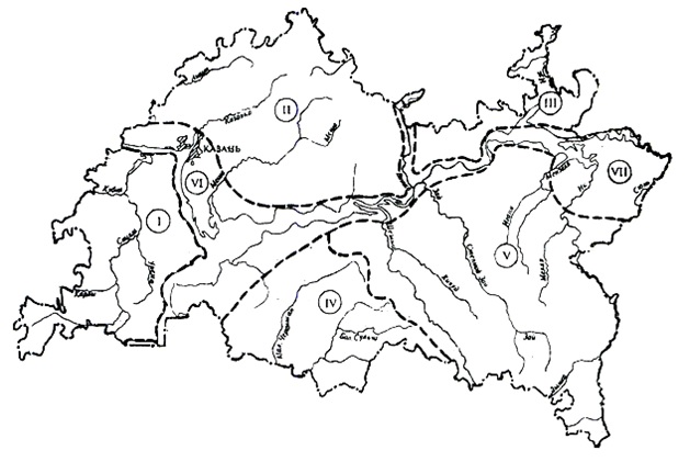
Figure 1 - Wetlands
Note: I – Predvolzhsky region, II – West Predkamsky, III – East Predkamsky region, IV – West Zakamsky, V – East Zakamsky region, VI – terrace area: along the Volga, Kama and Vyatka rivers, VII – Kamsko-Belsky district [3]
Marshes are long known as solar energy accumulators; it is compressed there in the substance of peat. Even Pliny the Elder in his Natural History called peat “inflammable earth” suitable for heating.
For a swamp to form, a combination of a number of conditions is necessary: climate humidity, proximity to groundwater, landscape features, waterproof soil layers. Not every swamp produces peat – neither in the steppes and deserts, nor in coastal swamps. Plant remains in the deserts decay quickly because of dry air and high temperatures; in coastal swamps, their rapid decomposition is promoted by salt water. In river creeks, quick flow and rich saturation of water with oxygen prevent formation of peatlands.
Peat accumulates in the bog very slowly: for example, it increases its thickness only by 0.5–1 mm per year, even in favourable conditions. This is the growth rate of the main peat-former: sphagnum moss. The process of converting dead plant parts into peat is very complex; thick layers of peat are formed for thousands of years, while these are developed (mined) in just a few years; after peat extraction, the swamp almost never recovers. And if a swamp dies, it means that the rivers originating in it become shallow, soil erosion begins, the whole landscape changes catastrophically.
Industrial extraction of peat on the territory of the Republic of Tatarstan has been carried out since the beginning of the 20th century. Initially, peat was used mainly for fuel by local industries. In 1959, the extraction of peat for fuel was stopped, but since 1940 peat is mined by agricultural enterprises to use it as a fertilizer for farmland. The scale of peat extraction especially increased in the 1960s and 70s. The volume of extraction in that period reached 400 thousand tons per year. By the end of the 20th century, peat reserves had largely dried up, the number of peat deposits had reduced, the area of peatlands had decreased, and since 1997, peat mining in the Republic of Tatarstan has ceased altogether
.It should be stressed that peat mining in the Republic of Tatarstan, which is territorially located in areas of unstable and insufficient moisture, is unacceptable and economically inefficient, since drainage reclamation leads to negative consequences: it disturbs the balance in nature not only of the wetlands themselves, but also of the adjacent territories.
4. Discussion
On the territory of the Republic of Tatarstan, with the support of the population, the administration solves many environmental problems. Laws are being adopted; programs and strategies are being drawn up to restore the natural environment. One of these documents is the “Strategy for the development of forestry in the Republic of Tatarstan until 2030” .
In 2023, the silvicultural season is open in Tatarstan. The work is carried out within the framework of the national project “Ecology”; and it is bearing fruit. For example, until 1953, the forest cover was 17.1%, and, as a result of the creation of the Kuibyshev reservoir, the forest cover decreased to 15.8%
. In 2004, the forest cover of the Republic of Tatarstan grew to 17.2%. Today, the forest cover in the republic is 17.5 % . All this suggests that great attention is paid to reforestation in the Republic of Tatarstan.But, as it was accentuated in the Introduction, above woods, there exists another beneficial agent — wetlands — which is capable of stabilizing the acceleration of global warming even stronger than reforestration.
Wetlands of Tatarstan occupy only 0.42%, but in local areas, swamps and marshes can take up more than 5% of the territory.
According to our data, in the Republic of Tatarstan there are more than 7 thousand swamps, and their total area is 284.7 km2. Of these, about 6 thousand, with a total area of 253.5 km2, are developed in floodplains and on low floodplain terraces. The largest Kulyagash swamp (49 km2) is located in the east of the republic at the confluence of two rivers (Kama and Belaya). Large swamps (more than 100 hectares) are also located in river valleys.
On the territory of Tatarstan, surface watercourses originate from numerous swamps, and wetlands initially participate in the formation of a runoff, but the main thing is that, as a link in a single hydrological network, they become water accumulators and flow regulators. Lakes and reservoirs play a dominant role in the formation of bogs in the region. Many lakes have formed in the valleys, which play the greatest role in the marsh formation of the region. Here, in the middle of the 20th century, there were almost 10 thousand lakes, of which more than 1 thousand have turned into swamps today
. Several large reservoirs and hundreds of small ponds have been created on the rivers of Tatarstan, including the Kuibyshev reservoir, with an area of 6500 km2. In the shallow zone of this reservoir, which occupies 25% of its area, wetland vegetation is developed.One of the important functions of wetlands is the regulation of water quality, which is manifested in the mechanical filter retention of various impurities and sediments of water entering the swamp, as well as in the decomposition of organic substances by microorganisms. The densely populated eastern regions of Tatarstan, being a region of intensive oil and gas production, experience a shortage of drinking water despite the dense river network and a large number of springs. The use of the filtration capacity of bogs and wetlands in such highly industrial regions would make it possible to develop measures for the purification of polluted waters by creating natural biological filters based on marsh vegetation.
Swamps, bogs, and all wetlands in general play an important role in the food chain. In the Republic of Tatarstan, as in other regions, they contribute to the conservation of biodiversity and serve as a food base for migratory birds. In the vast thickets of reeds in the shallow waters of the coastal strip of the Kuibyshev and Nizhnekamsk reservoirs, in the valleys of large rivers (Volga, Kama, Belaya), a huge number of waterfowl nest. Long-term fluctuations in their numbers in the pre-fishing period vary from 28 to 30 thousand individuals in the Nizhnekamsk and from 11 to 30 thousand in the Kuibyshev reservoirs. Birds also adhere to the valleys of large rivers during the migration period
. Waterfowl in their seasonal migrations can cross borders and therefore should be considered, according to the Convention on Wetlands (Ramsar, Iran, 1971), as an international resource .5. Conclusion
The complex nature of wetlands makes them unique ecosystems, and their role seems to be underestimated up to now – whereas in monitoring and modeling climate change, in working out any programs of stabilization and correction of global warming and the like, these ecosystems should be inevitably and immediately taken into account.
Being a connecting and transitional link between water and land, wetlands prove to be indispensable components of the landscape, and an important parameter in ecosystem modeling.
Carrying out the works on the restoration of the wetland complex, during reclamation and artificial swamping, it is essential to know the genetic characteristics of wetland complexes in the area under consideration, as well as the features of the landscape in which they were formed, that is, climatic conditions, lithology and terrain, since each landscape has its own individuality and requires a personal approach.
In the course of this study, the first catalog and a map of swamps, marshes, bogs, and wetlands for the Republic of Tatarstan were compiled and constructed; the geomorphological classification of swamps is given; swampy areas identified.
For now, it is very urgent to enlighten and educate public and to stir up the administrative resource of Tatarstan – and certainly not of Tatarstan only – to create adequate attitudes to the wetlands, to preserve them and realize their immense role in ecology, mainly in dealing with the acute problem of climate change.