СЕЙСМОРАЗВЕДОЧНЫЕ ИССЛЕДОВАНИЯ СЕВЕРО-ВОСТОКА ЯКУТИИ
СЕЙСМОРАЗВЕДОЧНЫЕ ИССЛЕДОВАНИЯ СЕВЕРО-ВОСТОКА ЯКУТИИ
Аннотация
Приведены данные о методике, выполненных объемах и полученных результатах выполненных в 1976-1992 гг. сейсморазведочных работах МОГТ в Зырянской, Томпонской впадинах, Тастахском прогибе Северо-Востока Якутии и рассматриваются вопросы их сопоставления с материалами по примыкающему шельфу моря Лаптевых. Показана возможность выделения на временных разрезах и интерпретации синхронных осадочных комплексов впадины, прогибов, шельфа. Полевые сейсморазведочные материалы характеризуются качеством пригодным для переобработки.
1. Introduction
One of the important tasks of modern Russia is the development of the Arctic, as it contains huge reserves of strategic resources.
The most probable volumes of initial hydrocarbon resources (HC) of the north-eastern Arctic shelf of Russia are estimated in the following volumes: Laptevskaya NGO (oil and gas bearing region): oil (extracted) – 2,3 billion tons, free gas – 4,2 trillion.m3; Eastern Arctic NGO: oil (extracted) – 6,0 billion tons, free gas – 4,7 trillion.m3; Novosibirsk-Chukotka NGO: oil (extracted) – 0,7 billion tons, free gas – 1,1 trillion m3 , .
The oil and gas industry of the republic is characterized by stable and progressive development. The Republic of Sakha (Yakutia) is increasingly mastering a new economic specialization, becoming the largest center of oil and gas production , .
2. Research methods and principles
Seismic surveys for oil and gas in a limited volume were carried out in 1979-1992. JSC "Yakutskgeofizika" (JAGF) in the continental part of the Northeast of Yakutia within the Zyryanka cavity and the Tastakh trough . The total volume of seismic surveys carried out by the method of the common depth point (SMT) in these areas amounted to 3889 km. In the Zyryanka cavity, 2,709 km of MOGT were performed, of which 948 km of 6-fold MOGT and 1151 km of 12-fold MOGT. In the Tastakh deflection, 1,180 pg. km of MOGT were worked out, of which 307 pg. km of 6-fold MOGT and 873 pg. km of 12 – fold MOGT. The density of the profile network in the studied parts of the Tastakh trough was 1.3 km/km2 and 0.6 km/km2 in the Zyryanka cavity. At the initial stage of field research, a 6-fold flanking observation system was used with the removal of the explosion point (PV) – 300 m, the pitch of the PV – 113-100 m, grouping of 20 seismic receivers on a base of 100 m, the length of the arrangement 1175 m, the type of excitation – linear surface sources (LPI), grouping – 11 charges on the base 100 m, charge weight 0,4-0,8 kg. Also, a flanking 6-fold observation system was used with the removal of the receiving point (PP)-300 m, the pitch of the PV—100 m, the grouping of seismic receivers (SP) – 21 pieces based on 100 m, the length of the arrangement 1175 m, the source of vibrations is the vibrator SV-5-15 (sledge version), the grouping-vanie sources – 3-4 vibrators based on 100 m. Subsequently, based on the results of experimental work, the following methodology was developed: a central 12-fold observation system of the SMT; removal of PV-25m; step PV-100m; step SP-25m; grouping 11 SP based on 50m. In addition, a flanking 12-fold observation system was used, the PV step was 50m, the SP step was 25m. The type of excitation is explosive, single borehole charges, the weight of the charge is 4kg, the depth of the well is 10m. Seismic stations "Progress-3". The processing of materials was carried out using the software package "PRMAX" in the specialized information and computer center (ICC) of the JAGF.
3. Main results
According to the results of the work carried out, the geological structure of the Zyryanka cavity and the Tastakh trough has been clarified. Reflective horizons characterizing the sedimentary performance of the deflection and cavity are revealed. Reflective boundaries with zonal traceability have been traced on individual seismic profiles (Fig. 1, 2, 3, 4, 5). A number of structural maps have been constructed based on the revealed reflecting horizons in Meso-Cenozoic sediments. Promising objects for parametric drilling have been identified and recommended .
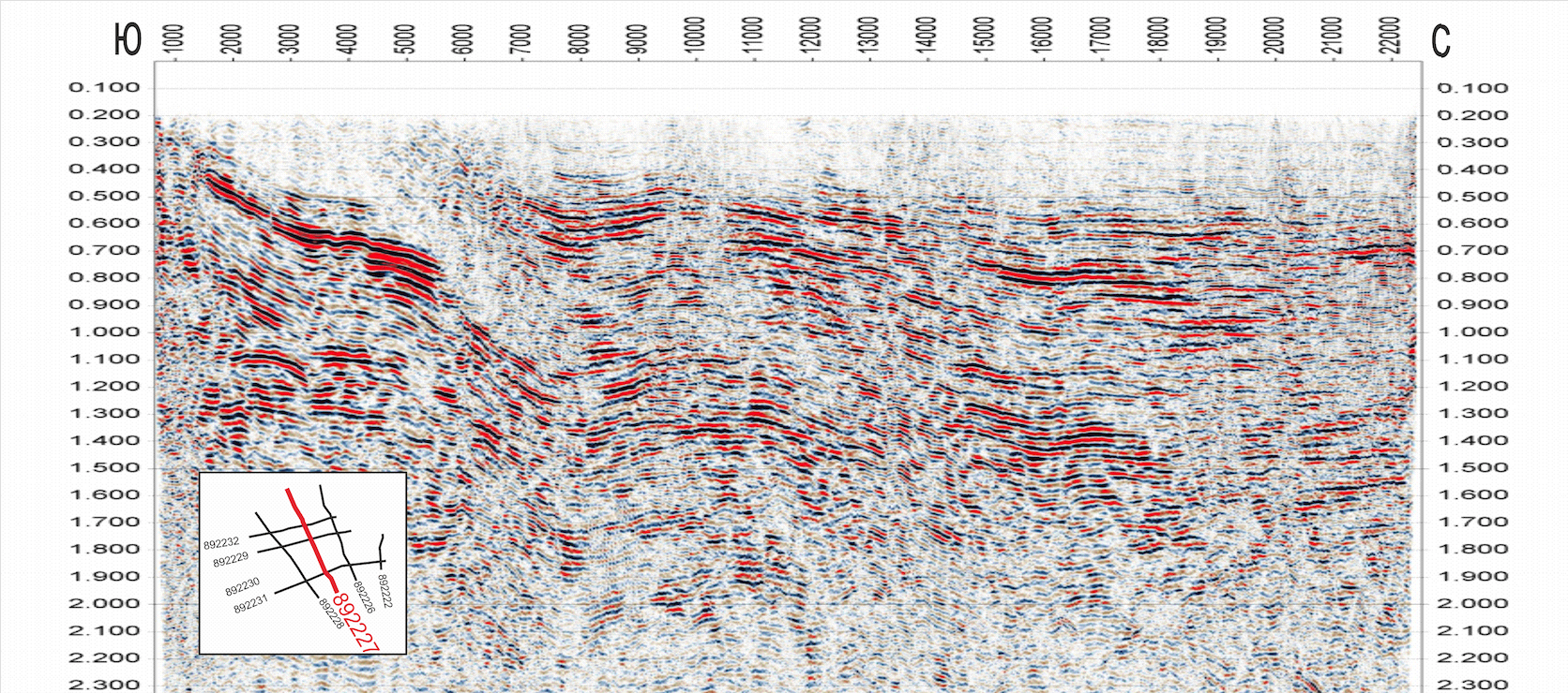
Figure 1 - Seismic section of PR 892227 – Zyryanskaya cavity, JAGF
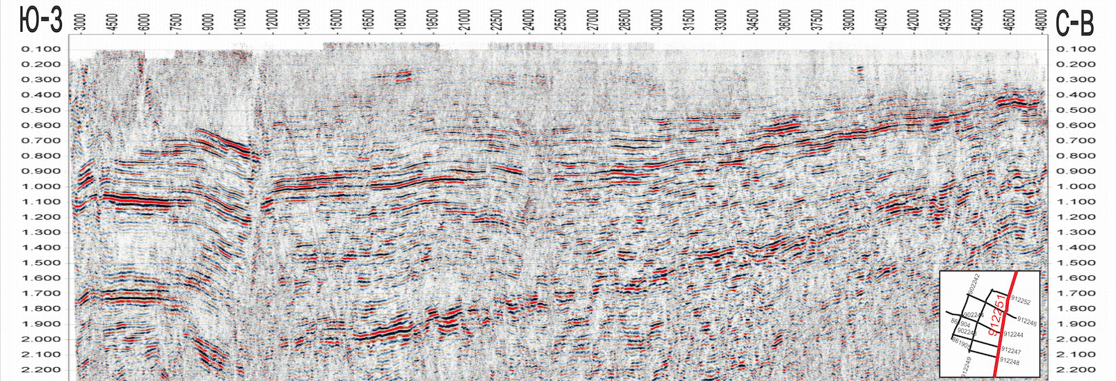
Figure 2 - Seismic section of PR 912251 – Zyryanskaya cavity, JAGF
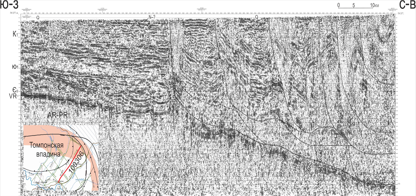
Figure 3 - Seismic section of PR 100306 – Thompson cavity, JAGF
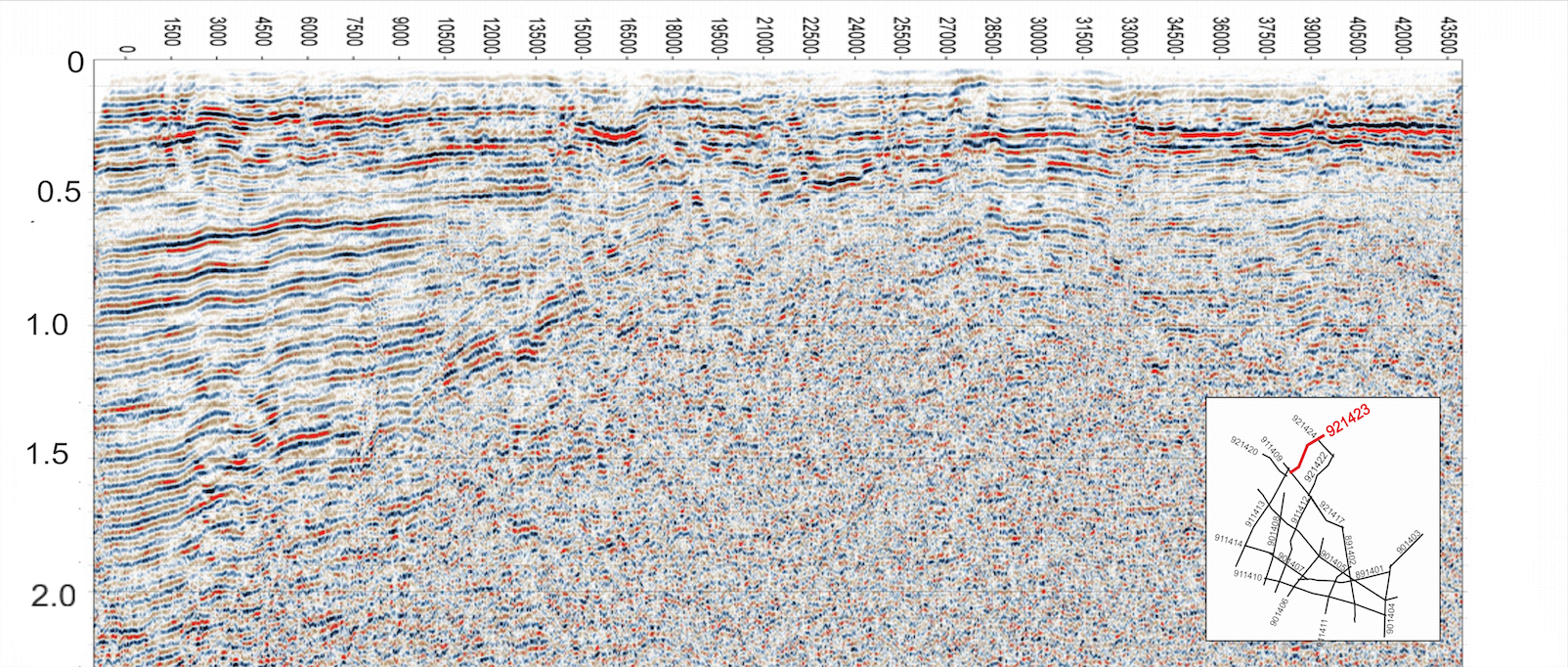
Figure 4 - Seismic section of PR 921423 – Tastakh cavity, JAGF
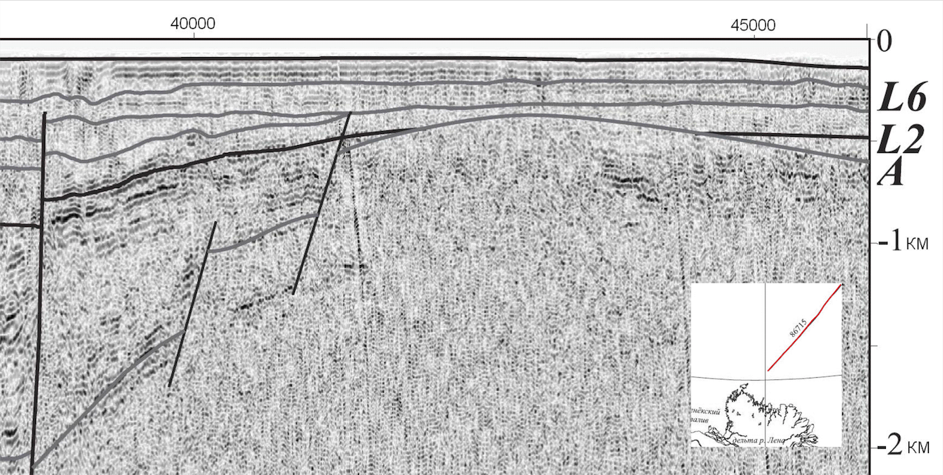
Figure 5 - Fragment of a deep section according to profile 86715
Note: copy from GC S-51.52
The Zyryanka depression in the seismic wave field is represented by thin-layered, unstressed, poorly differentiated, low-amplitude reflected waves complicated by wave interference of a wide spectrum, of various types. According to the results of the work, the presence of anticlines was established, which are localized in the inner axial part of the cavity. An extensive zone of wedging of the Lower Cretaceous strata is planned in the northern instrument part of the cavity. Within its limits, a wide development of non-anticlinal hydrocarbon traps is expected .
In the 2010-2012 season JAGF, commissioned by Rosnedra, conducted regional seismic surveys (Severo-Khandygskaya s/p No. 03 /10-12) in the Tompon depression complicating the Aldan branch of the Preverkhoyansk trough . The following method of field work was used: central MOGT x60; step PP-50m; placement length – 3000 x 2 m; grouping 11 SP on the basis of 50 m; excitation source vibrators SV 20/150 3 pcs. on the basis of 50 m; 1405,1 g.km were worked out. The processing of materials was carried out in the YAGF ICCF. The reflected waves were traced Y1 – the sole of the Lower Jurassic sediments, Y2 - (K״) – the sole of the Inican formation of the Middle Cambrian, VR – (K') – the sole of the Yudoma formation of the Vendian, R3 – (R2) (KV1) – the sole of the upper Riphean (Fig. 3). In addition, reflected waves from Lower–Upper Cretaceous and Neogene-Quaternary deposits are present in the wave field (Fig. 2). The surface seismogeological conditions are generally favorable for the work.
The speed of the forward wave in the first intro varies significantly, from 3200 to 4800 m/sec. A refractive boundary is associated with the Jurassic-Cambrian interface, from which a refracted wave with a velocity of 5000-6500 m/sec is traced in the first introductions. According to the results of the work, it was found that the thickness of Mesozoic sediments increases significantly to the north, northeast as the sedimentary cover sinks towards the Pre-Verkhoyansk trough to a depth of 15 km (Fig. 3). In the north-east of the area, a zone of erosion of Vendcambrian sediments during the pre-Jurassic break was revealed. In the pre-thrust zone of the Aldan segment of the Verkhoyano-Kolyma folded region, the Tompruksko-Kitschan zone of early Cretaceous age was revealed, overlain with a break and erosion by Quaternary sediments. Seismostratigraphy methods in the Tompon cavity have established the manifestation of riftogenesis of Late Vendian age (Fig. 3) .
4. Discussion
In recent years, a number of industrial and scientific organizations have begun seismic surveys of the shelf of the Laptev, East Siberian and Chukchi seas. The results of the Laptev Sea research are summarized in explanatory notes to the published State Geological Maps of the Russian Federation on a scale of 1:1000000 , . The analysis of published and stock materials allowed us to outline the similarity of time sections along the seismic profiles of the structures of the Pre-Verkhoyansk trough, the Verkhoyano-Kolyma mountain-folded region and the adjacent shelf. Thus, in the section of the Zyryansk cavity, the Tastakh trough and the Aldan branch of the Preverkhoyansk trough, Paleogene deposits are present, assumed in the most bent depressions of the shelf of the northeastern seas (Fig. 1, 2, 4) , . The Lower Cretaceous sediments of the Tompon depression are broken through by the Tomporuk-Kitchan zone of thrust dislocations of the Late Cretaceous stage of activation of the Verkhoyano-Kolyma mountain-folded region (Fig. 3). Seismophations of Neogene-Quaternary sediments in the presented sections overlap the Kitchen-Tomporuk thrust zone, intermountain depressions of the Verkhoyano-Kolyma folded zone, compose the upper part of the sections of the Primorsky plain and shelf (Fig. 3). As an example, a copy of a temporary section from the materials of the GC 1000 is shown . As can be seen on the fragment of the section on the profile 86715 (Fig. 5), the wave pattern has a similarity with the time section on the profile 921423 (Fig. 4). On both sections there is a seismophation associated with Neogene – Quaternary deposits overlapping the slope of the buried uplift. The accumulation of the underlying sediments followed the type of plantar abutment. Under the Tastakh deflection, the South Anyu structural zone is distinguished (Fig. 4), the planned position of which is debated . Seismic survey materials on the Tomponsky and Tastakhsky deflections are of interest from the point of view of studying geodynamic issues. In the North-Eastern part of the Republic of Sakha (Yakutia), seismic exploration works of various organizations revealed a number of anticlinal structures. Promising objects are monitored as controlled oil and gas bearing ones with a fairly high predicted hydrocarbon potential , , .
5. Conclusion
Seismic survey materials of the Tastakh trough and the Zyryansk cavity are characterized by a quality suitable for reprocessing, the need for which becomes obvious in the light of discussions about the structure and geological development of the Verkhoyano-Kolyma mountain-folded region and the adjacent shelf. The data presented on the results of the study of cavity structural elements in the northeast of Yakutia by the seismic survey of MOGT-2D confirm the well-known thesis about the potential oil and gas potential of these territories. To assess the forecast hydrocarbon resources, their further study is required together with the shelf of the Laptev and East Siberian Seas.
