ИНФОРМАЦИОННАЯ ПОДДЕРЖКА ПРИНЯТИЯ РЕШЕНИЙ ПО УПРАВЛЕНИЮ РЕГИОНОМ НА ОСНОВЕ ТЕХНОЛОГИИ ИНТЕГРАЦИИ ТРЕХМЕРНЫХ МОДЕЛЕЙ ПОТЕНЦИАЛЬНО ОПАСНЫХ ОБЪЕКТОВ С ГЕОИНФОРМАЦИОННОЙ СИСТЕМОЙ ОРГАНОВ ИСПОЛНИТЕЛЬНОЙ ВЛАСТИ
Павлов С.В.1, Ефремова О.А.2, Соколова А.В.3
1Доктор технических наук, Профессор, 2Кандидат технических наук, Доцент, 3Магистр по информационным системам и технологиям, Аспирант, Уфимский Государственный Авиационный Технический Университет (УГАТУ)
ИНФОРМАЦИОННАЯ ПОДДЕРЖКА ПРИНЯТИЯ РЕШЕНИЙ ПО УПРАВЛЕНИЮ РЕГИОНОМ НА ОСНОВЕ ТЕХНОЛОГИИ ИНТЕГРАЦИИ ТРЕХМЕРНЫХ МОДЕЛЕЙ ПОТЕНЦИАЛЬНО ОПАСНЫХ ОБЪЕКТОВ С ГЕОИНФОРМАЦИОННОЙ СИСТЕМОЙ ОРГАНОВ ИСПОЛНИТЕЛЬНОЙ ВЛАСТИ
Аннотация
В статье рассматривается технология интеграции трехмерных моделей потенциально опасных объектов в Геоинформационную систему органов исполнительной власти (на примере Республики Башкортостан).
В качестве одного из подходов к ее решению предложена интеграция на основе сервис-ориентированного подхода, для чего введено теоретико-множественное описание пространственной информации в составе трехмерных моделей. Предложенная технология предусматривает интеграцию как на уровне данных и так и на уровне сервисов.
Интеграция трехмерных моделей потенциально опасных объектов в Геоинформационную систему органов исполнительной власти позволит сократить время и увеличить точность принимаемых решений в случае возникновения чрезвычайной ситуации за счет предоставления полного объема необходимой информации о ее развитии в более наглядном и доступном для понимания виде средствами единой системы.
Ключевые слова: технология интеграции; потенциально опасные объекты; геоинформационная система.Pavlov S.V.1, Efremova O.A.2, Sokolova A.V.3
1PhD in Engineering, Professor, 2PhD in Engineering, Associate Professor, 3Master of information systems and technologies, Postgraduate student, Ufa State Aviation Technical University
INFORMATION DECISION SUPPORT OF REGION MANAGEMENT ON THE BASIS OF INTEGRATION TECHNOLOGY OF POTENTIALLY DANGEROUS OBJECTS THREE-DIMENSIONAL MODELS WITH GEOGRAPHIC INFORMATION SYSTEM OF THE EXECUTIVE AGENCIES
Abstract
The article discusses the technology integration of three-dimensional models of potentially dangerous objects in geoinformation system of executive agencies (on the Republic Bashkortostan example).
As one of the approaches to its solution offered on the basis of the integration of service-oriented approach, which introduced the set-theoretic description of the spatial information as part of three-dimensional models. The proposed technology provides for the integration of both the data and the level and the service level.
The integration of three-dimensional models of potentially dangerous objects in geoinformation system of executive agencies will reduce the time and increase the accuracy of the decisions taken in the event of an emergency at the expense of the full amount of the required information about its development in a more visual and understandable form by means of a single system.
Keywords: the technology of integration; potentially dangerous objects; Geographic information system.Introduction
Bashkortostan is one of the major steadily developing industrial regions of the Russian Federation. To management the region it is to use of information that characterizes the region as an object with natural geographic, socio-demographic, and economic, infrastructure, and other characteristics, and features. Given the diverse nature of the information, a large amount and spatial distribution in the region of its processing is not possible without the use of modern information systems for the collection, storage, analysis and graphical visualization of spatial data. One such system is the Geographic information system of the executive agencies of the Republic of Bashkortostan (GIS EA RB).
Based on the fact that the process of supporting enterprise management solutions republic in the event of various types of emergencies require to provide the most complete information about the object, for which there was an emergency, information about the objects in three dimensions need to be integrated in the form of three-dimensional models in the GIS EA RB (Figure 1).
Three-dimensional model of a potentially dangerous object
Model is based on a variety of cartographic materials: city plans, aerial and satellite images, large-scale maps, digital elevation model, raster images and other materials that can be used separately or together. In this three-dimensional model of potentially dangerous objects enables the integration of information about all kinds of spatial objects within its territory and can be defined by the following set of elements:
![]() (1)
(1)
where D - spatial data set of the object; F - function of transformation of spatial data in the three-dimensional image; P - visualization project of three-dimensional model.
In turn, the set of spatial information included in the three-dimensional model of a potentially dangerous object is described as follows [1,P.180]:
![]() (2)
(2)
where V - vector data stored in a geodatabase and describe three-dimensional information on the facilities located on the territory of a potentially dangerous object (communication structures, terrain, etc.);
R - raster data satellite imagery site, evacuation plans, etc.);
T - data on an earth surface stored in the form of triangulation networks.
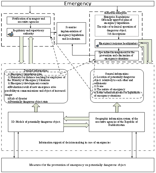
Fig. 1 – The scheme of the process of information management decision-making support in the republic case of an emergency
Integration of three-dimensional models of potentially dangerous objects in the GIS ЕА RB
In general, the structure of the Geographic Information System of the executive agencies of the Republic of Bashkortostan can be described as follows [2, P. 88]:
![]() (3)
(3)
where F - the set of spatial data; A - the set of spatial data processing services.
Integration of three-dimensional models of potentially dangerous objects in GIS EA RB may be implemented through the development of additional service L – service of three-dimensional visualization, which is a set of codes of spatial data sources of the three-dimensional models of potentially dangerous objects CL and many characteristics of service HL:
![]() (4)
(4)
This is representation allows to integrate developed three-dimensional models of potentially dangerous objects in GIS EA RB for providing information for decision support in the event of an emergency and the elimination of its consequences on the territory of the republic [3, 4, P.70].
Conclusion
The paper provides a solution to the problems of integration of three-dimensional models of potentially dangerous objects, designed based on service-oriented architecture of Geographic information systems executive agencies of the Republic of Bashkortostan, which introduced a set-theoretic description of the spatial information as part of three-dimensional models.
Список литературы / References
- Гизатуллин А. Р., Соколова А. В. Трехмерное моделирование инженерных коммуникаций в ГИС / А. Р. Гизатуллин, А. В. Соколова // Геоинформационные технологии в проектировании и создании корпоративных информационных систем: межвузовский научный сборник Уфа: УГАТУ. – 2013. – C. 176-185.
- Павлов С. В., Ефремова О. А., Павлов А. С., Информационная вычислительная система для обеспечения органов исполнительной власти региона пространственными данными / С. В. Павлов, О. А. Ефремова, А. С. Павлов // Электротехнические и информационные комплексы и системы. – 2013. – Т. 9. – №2. – С. 88-95.
- Павлов С. В., Ефремова О. А., Ямалов И. У. Интеграция пространственной информации в Геоинформационной системе органов исполнительной власти на основе сервис-ориентированной архитектуры / С. В. Павлов, О. А. Ефремова, И. У. Ямалов // Вестник УГАТУ. – 2013. – Т. 17. – №.5 (58). – С.129-139.
- Павлов С. В., Ефремова О. А., Соколова А. В Формализованное описание пространственной информации в составе трехмерных моделей потенциально опасных объектов на основе теоретико-множественного подхода / С. В. Павлов, О. А. Ефремов, А. В. Соколова // Электротехнические и информационные комплексы и системы. – 2014. – Т. 10. – №1. – С. 66-72.
Список литературы на английском языке / References in English
- Gizatullin A. R., Sokolova A. V. Trehmernoe modelirovanie inzhenernyh kommunikacij v GIS [Three-dimensional modeling of engineering communications in GIS] / A. R. Gizatullin, A. V. Sokolova // Geoinformacionnye tehnologii v proektirovanii i sozdanii korporativnyh informacionnyh system: mezhvuzovskij nauchnyj sbornik Ufa: UGATU [Interuniversity scientific collection: GIS technology in the design and development of enterprise information systems, USATU, Ufa, Russia]. – 2013. – P. 176-185. [in Russian]
- Pavlov S. V., Efremova O. A., Pavlov A. S. Informacionnaja vychislitel'naja sistema dlja obespechenija organov ispolnitel'noj vlasti regiona prostranstvennymi dannymi [Information-computer system for providing regional executive agencies with spatial data] / S. V. Pavlov, O. A. Efremova, A. S. Pavlov // Jelektrotehnicheskie i informacionnye kompleksy i sistemy [Electrical and data processing facilities and systems]. – 2013 – V. 9. – №2. – P. 88-95. [in Rusian]
- Pavlov S. V., Efremova O. A., Yamalov I. U. Integracija prostranstvennoj informacii v Geoinformacionnoj sisteme organov ispolnitel'noj vlasti na osnove servis-orientirovannoj arhitektury [Integration of Spatial Information in Geographic information system of executive agencies on the basis of service-oriented architecture] / S. V. Pavlov, O. A. Efremova, I. U. Yamalov // Vestnik UGATU [Vestnik UGATU]. – 2013. – V. 17. – №.5(58). – P.129 -139. [in Russian]
- Pavlov S. V., Efremova O. A., Sokolova A. V., Formalizovannoe opisanie prostranstvennoj informacii v sostave trehmernyh modelej potencial'no opasnyh ob#ektov na osnove teoretiko-mnozhestvennogo podhoda [Formalized description of the spatial information as part of three-dimensional models of potentially dangerous objects on the basis of the set-theoretic approach] / S. V. Pavlov, O. A. Efremova, A. V. Sokolova // Jelektrotehnicheskie i informacionnye kompleksy i sistemy [Electrical and data processing facilities and systems]. – 2014. – V. 10. – № 1. – P. 66-72. [in Russian]